Image

Avon River - Avon York

Basin : Avon River

Catchment : Avon River

River condition of the Avon York site (site code: SA388AVON1, site reference: 6154194) on the Avon River was assessed between 13 and 14 November 2023. Results are compared with previous assessments.

Healthy Rivers assessments are conducted using standard methods from the South West Index of River Condition (SWIRC), which incorporates field and desktop data from the site and from the broader catchment. Field data collected include the following indicators, assessed over about a 100 m length of stream:

  • Aquatic biota: fish and crayfish community information (abundance of native and exotic species across size classes, general reproductive and physical condition)
  • Water quality: dissolved oxygen, temperature, specific conductivity, and pH (logged in situ over 24 hours) as well as laboratory samples for colour, alkalinity, turbidity and nutrients
  • Aquatic habitat: e.g. water depth, substrate type, presence of woody debris and detritus, type and cover of macrophytes and draping vegetation
  • Physical form: channel morphology, bank slope and shape, bioconnectivity (barriers to migration of aquatic species), erosion and sedimentation
  • Fringing zone: width and length of vegetation cover within the river corridor and lands immediately adjacent, structural intactness of riparian and streamside vegetation
  • Hydrology: measures of flow (velocity) at representative locations (compared against data from stream gauging stations within the system)
  • Local land use: descriptions of local land use types and activities (compared against land use mapping information for the catchment)

The site was previously assessed during November 2019.

This site was one of four assessed on the Avon and Dale rivers during November 2023; the other sites were Avon Pelham Brook (in Toodyay), Gwambygine Pool and Reserve Pool.

Other departmental data: The Avon York site is about 750 m downstream of the Department of Water and Environmental Regulation’s (the department) flow gauging station on the Avon River known as Balladong Street York (site reference: 615024), which has been in operation since 1995.

Search the site code or site reference in the department's Water Information Reporting (WIR) system to find data for this site and nearby sampling points (flows, surface water quality, groundwater monitoring, the department's meteorological data). See also the Bureau of Meteorology website for additional meteorological data for the area.

Condition summary

The image below indicates the conditions at the Avon York site in November 2023. November is within the Noongar season of Kambarang (second spring), which is traditionally seen as a transformational time of year with many plants flowering. The season is marked by longer periods of dry weather and rising temperatures. Further images are provided in the gallery at the bottom of the page to show general site conditions and features.

A summary of site condition over the latest monitoring period is provided in the sections below. For other site data, please contact the department’s River Science team (please reference the site code and sampling dates).

River setting

The Swan-Avon catchment is the largest catchment in south-west Western Australia, covering over 120,000 km2. It is climatically and geologically diverse. The mainstem of the Avon River has its headwaters at Lake Yealering, 40 km east of Pingelly. It travels northwards, joins the Dale River and passes through Beverley, York, Northam and Toodyay before turning east and then south-east as the river traverses the Darling Scarp before it joins Wooroloo Brook, where the Avon River becomes the Swan River.

The Avon York site is on the Avon River in the Wheatbelt town of York, about 90 km east of Perth. Prior to European settlement, the Avon River in Noongar Ballardong country was a braided river, with many small channels amongst vegetated islands and with deep, well-shaded pools.

Historically, the Avon River has been disturbed by two activities: clearance of woodland for agriculture, and ‘training’ of the river channel to abate flooding. These two activities mobilised the salt that was long established deep in the soil, and the coarse riverbed sediments, respectively.

The cumulative effects of land clearing, eutrophication, salinisation, sedimentation and the river training scheme resulted in a highly degraded catchment and river system. However, as awareness has increased over recent decades, significant investment and progress has been made to fence, revegetate and protect the Avon River channel. It is estimated at least 95 per cent of the Avon River has been fenced and that significant recovery of riparian vegetation has occurred as a result (NRM Wheatbelt 2013). However, fencing needs constant maintenance, and the current condition of the fencing is unknown.

The Avon York site is in a meandering plane-bed channel within a broad river valley; this is characteristic of the Avon River in the Wheatbelt. Monger’s Crossing causeway crosses the channel mid-site, creating a deeper, pool-like habitat upstream (Bland’s Pool). Bland’s Pool is about 1 km long and 30–40 m wide and maintains water throughout the year (acting as a refuge habitat) but is disconnected from the broader river system for much of the year. The section of channel downstream of the causeway was shallower and therefore less likely to maintain permanent water throughout the hot, dry summer months.

The river is within a low-gradient section, and the active channel depth was greater than two metres on both banks, both upstream and downstream of the causeway. At the time of sampling, water depth varied, with an average depth of 1.5–2.0 m, but was greater than 2.0 m in the centre of the channel. Channel width was 30–40 m at the time of sampling and bankfull width was about 130 m. The banks were concave (with some sections of the bank having a wide lower benches). Bank slope varied from vertical to steep, with some moderately sloped banks mostly downstream of the causeway. The channel was mostly U-shaped with some stepped channel found at the downstream end of the site.

Aquatic habitat

Aquatic habitat was varied, with near-optimal woody debris, aquatic vegetation (see image below), as well as diverse biological and physical, substrates. Elevated salinity, sediment deposition and limited stream shading by riparian vegetation were indicators of suboptimal aquatic habitat.

Sampling occurred a few months after the end of the wet season, with flows and water levels in recession. Flows were maintaining a small riffle habitat through Mongers Crossing, at the downstream end of the assessment site. The crossing also supported a pool-like environment upstream (Bland’s Pool), indicated by fine sediment deposition and increased depth and width compared to the otherwise uniform river channel further downstream.

The site was not well shaded, with less than half the length of both banks shaded by trees, and with the canopy only extending around 2–3 m across the 35 m wide channel (average width). This may lead to adverse water temperatures during summer, but the deeper areas of the town pool upstream of the site may provide a temperature refuge for species.

Woody debris was slightly reduced from what would be expected naturally but was still diverse, with 2–3 sizes observed in moderate abundance throughout the site. The largest woody debris category (>50 cm diameter) was missing because of the loss of larger trees near the river. The streamside tree layer was dominated by smaller sheoaks (Casuarina spp.). In-stream, aquatic vegetation cover was considered optimal, with 70 per cent of the site covered with native species (see image above). All the vegetation observed was submerged and included Chara spp. (charophyte) and Ruppia spp. (vascular macrophyte). This abundance of instream vegetation provides critical instream habitat and food for invertebrates, smaller and juvenile fish, and substrate for epiphytes. Biological substrate cover was near optimal, covering about half the site in a moderate density of epiphytes, algae, detritus and leaves. Leaf packs provide habitat and food for benthic-dwelling species.

There were limited areas of overhanging banks or draping vegetation that typically increase habitat diversity in more pristine river systems. The site contained a moderate diversity of substrate, ranging from silt and clay (mostly upstream of the causeway) to pebble and gravel (mostly downstream of the causeway). Upstream of the causeway, there was obvious sand sedimentation with fine, soft sediment in places. This is unsurprising given the long history of erosion and scouring of sediment through the mainstem of the Avon River following clearing for agricultural development and the river training scheme.

Flow & connectivity

The surface hydrology of the Avon River is highly variable. Between 1996 and 2023, the department’s gauging station at Balladong Street (GS# 615024), which is about 750 m upstream of the assessment site, has recorded an average annual discharge of 80 gigalitres (GL), but with a standard deviation of 87 GL. Annually, the flow cycle has three main phases, typical of many river systems in the south-west of Western Australia:

  • bank flow – medium to high flows with occasional inundation of the floodplain
  • wet connected – connected pools allow biota to recolonise the broader aquatic habitat from the refuge pools and
  • wet isolated – pools provide refuge habitat but are disconnected (Wheatbelt NRM 2013).

The period of disconnection (wet isolated phase) over the dry and hot summer months, is likely to increase across the south-west of the state because of the effects of climate change. This is likely to have impacts on water quality and movement of aquatic species to support life history requirements.

The geomorphology and hydrogeology of the Avon River is complex and highly compartmentalised, with many localised aquifers and strong interaction between groundwater and surface water. It appears that water quality in the Avon River pools is locally influenced by these interactions, with horizontal seeping and vertical upwelling of either fresh and/or saline waters, particularly during summer months (Wheatbelt NRM 2013).

Based on records from DWER gauging stations along the Avon (at Toodyay, Northam and York) the Avon River dries to pools (wet disconnected flow phase) from late spring to early summer through to autumn. During this period, the pools are a critical refuge for aquatic fauna but are often under the greatest stress from water quality issues revolving around saline groundwater intrusions and increased incidence of potentially harmful algal blooms (e.g. cyanobacteria) due to eutrophication. The additional impact of sedimentation and filling of these pool refuges increases the threat to the ecological health of the system.

At the time of sampling the site was connected and flowing but would be expected to cease flowing over summer leaving the Bland’s Pool an isolated refuge. Water was observed flowing through eroded, lower sections of Monger’s crossing (see image below).

While the causeway creates a barrier for fish passage, it also helps maintain the pool habitat upstream (Bland’s Pool) and during winter and spring, when the river flows (wet connected flow phase), fish would be able to pass. Effectively, the causeway only slightly increases the period of disconnection for fish passage. It is not likely a significant barrier, especially when considering much of the rest of the river will dry, leaving only the pools of the Avon with water.

Vegetation

The riparian zone (containing species adapted to living at the interface between aquatic and terrestrial environments) varied in width due to the presence of anabranches and wetted depressions on both banks. The vegetation at the site consisted of a native tree canopy, mostly swamp sheoak (Casuarina obesa), with an exotic understory, typical of remnant vegetation in a disturbed or modified system.

On average, the riparian zone extended for about 30 m on the left bank and about 35 m on the right bank and was dominated by swamp sheoak, with some paperbarks and tea tree (Melaleuca spp.) present, as well as some reeds and rushes on the banks. The dominance of the sheoak is consistent with its greater tolerance of saline conditions. Overall, the tree and shrub layer were both reduced by historical human impact, and current efforts to revegetate the area are impacted by high winter flows. This is supported by the field observations noting both natural and planted juvenile trees and shrubs, in healthy condition, but limited in their extent throughout the site. The ground cover layer was present but largely exotic (pasture grasses) but with some native, salt-tolerant species present, e.g., sea heath (Frankenia pauciflora), particularly on the left bank.

Erosion was evident throughout most of the site and was relatively severe, especially downstream of the causeway. The erosion is because of high energy, scouring winter flows, and a legacy of the river training scheme. This is likely impacting the success of riparian revegetation efforts. The image below illustrates the importance of deep-rooted vegetation in stabilising banks, but with the limited observed recruitment of woody native vegetation that was observed, maintenance of channel integrity is at risk.

Water quality

Below is a graph of the water quality recorded during the 24-hour assessment.

Water quality was varied with suboptimal water temperature but optimal dissolved oxygen.

Water temperature exceeded the 25°C threshold1 for a short period at the end of the 24-hour assessment. While small and short-lived exceedances of the threshold are not expected to have significant chronic effects on aquatic fauna, it is reasonable to assume that conditions would worsen during the warmer summer months (extended and more significant exceedances of species preferences). Refuge from suboptimal water temperature would exist in deeper areas of the pool. The range in water temperature was <4°C (3.66°C), which is optimal, but this value is already close to the upper limit and is likely to increase over hotter summer months.

The concentration of dissolved oxygen in the water was optimal over the 24-hour assessment, never falling below 4 mg/L2. The diurnal range was only about 2 mg/L, which was also optimal.

Specific conductivity (which can be used as an indicator of salinity) was an average of 15.67 mS/cm over the 24-hour assessment period, which is in the mid-saline range. This is more saline than Gwambygine pool, about 12 km upstream (which was an average of 12.28 mS/cm) and demonstrates a localised freshening influence of the Dale River on the Avon. Salinity in the Avon River increases again moving downstream from the Dale River confluence based on past records from Healthy Rivers assessments and other projects (e.g., Avon algae monitoring project).

pH was optimal (average of 8.31) based on expectations of natural ranges for freshwater rivers of south-west Western Australia. Turbidity was 6.1 nephelometric turbidity units (NTU), which is the lower end of the moderate range. True colour was 50 true colour units (TCU), this was consistent with the field observations of slight tanning staining.

Nutrient concentrations were both moderate; total nitrogen was 1.16 mg/L and total phosphorus was 0.067 mg/L.


Footnote:

1 An upper limit for temperature is nominally set at 25°C based on the range recorded in sites where south-west native fish species are typically found to occur (Beatty et al. 2013).

2 A lower limit of 4 mg/L is taken from the SWIRC where it is used as a guideline limit for condition scoring. This level aligns with Beatty et al. (2013) where south-west native fish species were shown to typically reside in sites with levels above 4 mg/L.

Species found in subcatchment

This includes all species found within the subcatchment of the assessment site, from this and previous studies in the area. The photos are linked to more information about each species, including maps of where they are expected across the south-west.

Species found at the site

Fish and crayfish

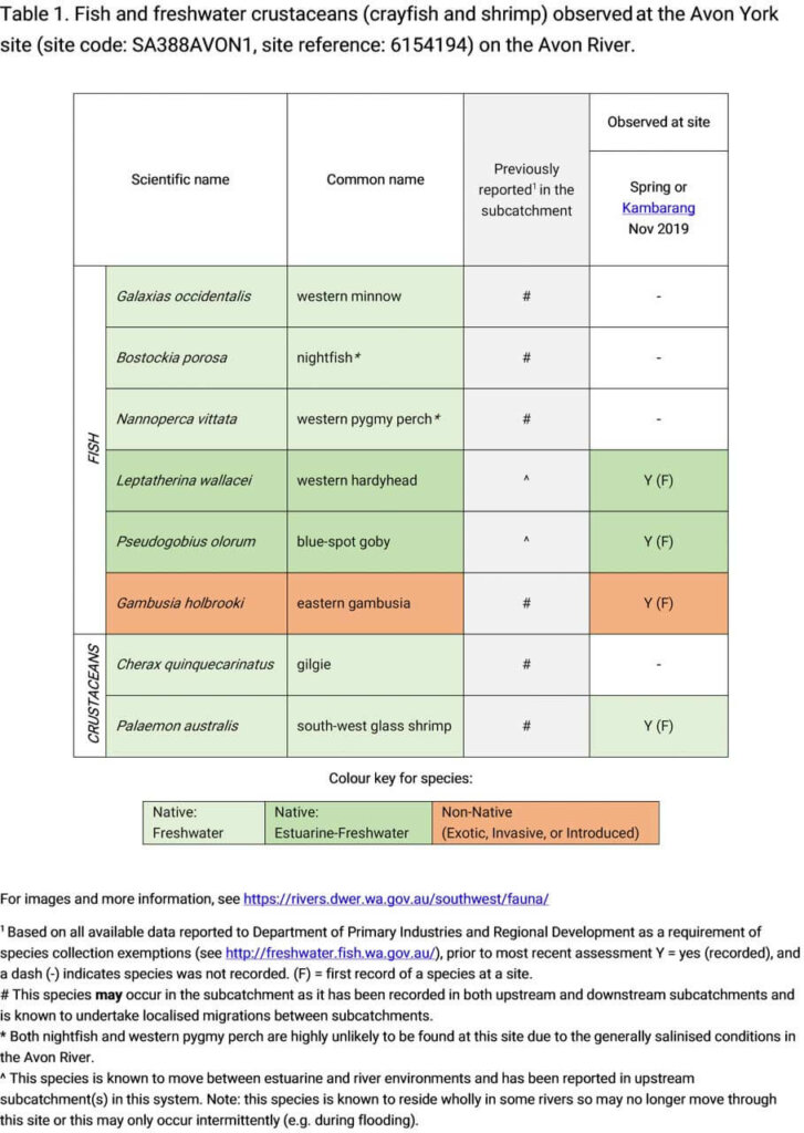
The species captured at the Avon York site during each of the assessments since 2019 are provided below in the table below. The species expected to occur here are based on species found at the site and elsewhere within the wider subcatchment. As differences in habitat within a reach naturally influence species distributions, and variability in methods between sampling programs can affect the species caught, this list is only indicative.

Four species of fish and one crustacean species were recorded during the 2023 sampling. This included three native fish species, one exotic species of fish and a native crustacean species. This is an increase in species detected from the previous assessment in 2019 as western minnows were detected for the first time. Western minnows are the most salt tolerant of the native freshwater fish species found in the south-west of the state and have been recorded further upstream in the Avon River. The exotic eastern gambusia (including juveniles and gravid adults), was also present which presents a risk to populations of native fish through competition and fin nipping.

The other two native fish species recorded at the site, blue-spot goby and western hardyhead, are considered estuarine opportunistic species, which have become established inland in the salinised Avon system. Juvenile blue-spot gobies were abundant, indicating a well-established population. The native freshwater crustacean, south-west glass shrimp, was also abundant.

The two freshwater species found in the catchment but not recorded at the site, nightfish and western pygmy perch, have been recorded in site upstream and downstream and would be expected to naturally inhabit the Avon-York site. Upstream detections were in the Dale River, which is much fresher than the Avon, and Gwambygine pool, which is freshened by water received from the Dale River. The two species may completely avoid or perish in the Avon-York site due to salinity exceeding tolerances or may move through the area during any short periods of fresher flow.

Note: collection of fauna from inland aquatic ecosystems across Western Australia requires a licence from the Department of Primary Industries and Regional Development (DPIRD) and the Department of Biodiversity, Conservation and Attractions (DBCA). All species collected must be reported to these agencies as part of licence conditions.


Other aquatic fauna

Only freshwater fish and crayfish that typically inhabit river channels are targeted by the standard SWIRC sampling methods; however, other species are sometimes captured or observed.  The following species were detected at the site:

  • south-western snake-necked turtle (Chelodina oblonga)
  • rakali (Hydromys chrysogaster) activity has been observed by local members of the York River Conservation Society (see image below, courtesy of the RCS York). This species is listed by DBCA as a Priority 4 species (rare, near-threatened and other species in need of monitoring).

For more information on these and other aquatic species, please see the River Science fauna page.