Goodga River - Black Cat Gauging Station
Basin : Albany Coast
Catchment : Goodga-Angove Rivers
River condition at the Black Cat Gauging Station site (site code: GR23GOOD1, site reference: 6021698 – previously reported as site code: GOO, site reference: 602199) on the Goodga River has been assessed as part of the Healthy Rivers Program (Healthy Rivers), using standard methods from the South West Index of River Condition (SWIRC). The SWIRC incorporates field and desktop data from the site and from the broader catchment. Field data collected include the following indicators, assessed over approximately a 100 m length of stream:
-
- Aquatic biota: fish and crayfish community information (abundance of native and exotic species across size classes, general reproductive and physical condition) and macroinvertebrates
- Water quality: dissolved oxygen, temperature, specific conductivity, and pH (logged in-situ over 24 hours) as well as laboratory samples for colour, alkalinity, turbidity and nutrients
- Aquatic habitat: e.g. water depth, substrate type, presence of woody debris and detritus, type and cover of macrophytes and draping vegetation
- Physical form: channel morphology, bank slope and shape, bioconnectivity (barriers to migration of aquatic species), erosion and sedimentation
- Fringing zone: width and length of vegetation cover within the river corridor and lands immediately adjacent, structural intactness of riparian and streamside vegetation
- Hydrology: measures of flow (velocity) at representative locations (compared against data from stream gauging stations within the system)
- Local land use: descriptions of local land use types and activities (compared against land use mapping information for the catchment)
This is the second assessment of this site using the SWIRC methods. Assessments are listed below:
- 2020 – summer (12-13 Mar): Healthy Rivers
- 2008 – spring (24-25 Nov): Healthy Rivers
- 1998 – current: this area has been sampled regularly by Murdoch University's Freshwater Fish Group (recorded in the fish expectations below), primarily to monitor the endangered trout minnow populations.
Other department data: The river health site extends upstream and downstream of the departments Black Cat flow gauging station (site reference: 602199). This gauging station has been in operation since 1963.
Search on the site code or site reference in the Department of Water and Environmental Regulation’s Water Information Reporting (WIR) system to find data for this site and nearby sampling points (flows, surface water quality, groundwater monitoring, the department's meteorological data). See also the Bureau of Meteorology website for additional meteorological data for the area.
Condition summary
A complete condition summary for this site has not yet been published. Please contact the department’s River Science team for site data (please provide the site code and sampling dates).
The previous assessment of this site in 2008 was part of a national assessment of river condition – view report here.
An overview of aquatic species found at the site is provided in the next section.
Species found in subcatchment
Native Species
- Balston's pygmy perchNannatherina balstoni
- Blue-spot gobyPseudogobius olorum
- Carter's freshwater musselWestralunio carteri
- Common jollytailGalaxias maculatus
- GilgieCherax quinquecarinatus
- KoonacCherax preissii
- Rakali - water ratHydromys chrysogaster
- Smooth marronCherax cainii
- South-west glass shrimpPalaemon australis
- South-western snake-necked turtleChelodina colliei
- Trout minnowGalaxias truttaceus
- Western hardyheadLeptatherina wallacei
- Western minnowGalaxias occidentalis
- Western mud minnowGalaxiella munda
- Western pygmy perchNannoperca vittata
Species found at the site
Fish and crayfish
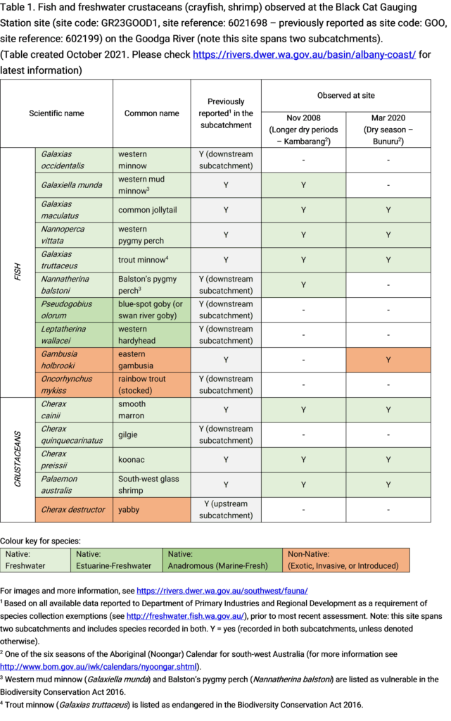
Eight native species and one non-native species were recorded at this site across November 2008 and March 2020 assessments. This includes five native fish (mud minnow, common jollytail, western pygmy perch, trout minnow, Balston’s pygmy perch) and three native crustaceans (smooth marron, koonac, south-west glass shrimp). The invasive non-native fish, gambusia, was recorded in the 2020 assessment. The mud minnow and Balston’s pygmy perch weren’t recorded in 2020, however both species were only found in low abundances in the 2008 assessment and may be present elsewhere in the catchment.
Dominant fish species at the site are the trout minnow and common jollytail. Notably the trout minnow is restricted to three river systems in Western Australia, the Goodga and Angove River systems east of Albany, and the Kent River west of Denmark.
This area is home to three species that have high conservational significance; this includes:
- Trout minnow – listed as endangered in the Biodiversity Conservation Act 2016
- Western mud minnow – listed as vulnerable in the Biodiversity Conservation Act 2016
- Balston’s pygmy perch – listed as vulnerable in the Biodiversity Conservation Act 2016
Several other species have been previously recorded in the area but were not found during assessments. This includes the native western minnow, blue-spot goby, western hardyhead, gilgie, and the non-native rainbow trout (historically stocked) and yabby. Note this assessment site spans across two subcatchments which encompass a variety of habitats. Based on recorded data these species were generally found to occur further upstream or downstream of the area assessed.
Only fish and freshwater crustaceans (crayfish and shrimp) that typically inhabit river channels are targeted by the standard SWIRC sampling methods. However, where other species were caught and/or observed (e.g., turtles, rakali-native water rats, tadpoles), these are mentioned in the Other aquatic fauna section below.
Note: collection of fauna from inland aquatic ecosystems across Western Australia requires a license from the Department of Primary Industries and Regional Development (DPIRD) and also the Department of Biodiversity, Conservation and Attractions (DBCA). All species collected must be reported to these agencies as part of license conditions.
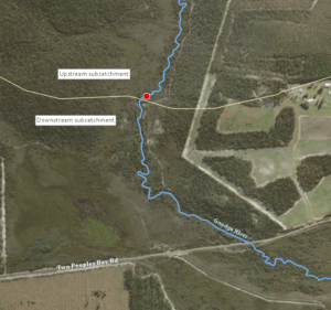
Goodga River subcatchment boundary
Aquatic macroinvertebrates
Macroinvertebrates were collected during the November 2008 assessments, please contact the department’s River Science team if you are interested in the site data (please provide the site code and sampling dates).
Other aquatic fauna
Although not targeted by collection methods a south-western long necked turtle (Chelodina colliei) and native rakali water rat (Hydromys chrysogaster) were recorded during March 2020 assessments.
Carter’s freshwater mussel (Westralunio carteri) have previously been recorded in the downstream subcatchment, but were not observed during assessments.
For more information on aquatic species, please see the River Science fauna page here.


