Susannah Brook - Reserve No 50069
Basin : Swan-Coastal
Catchment : Swan-Avon River - Lower Swan River
The condition of Susannah Brook - Reserve No 50069 (site code: SR241SUSA1, site reference: 6167212) was assessed between 16–17 November 2022.
Healthy Rivers assessments are conducted using standard methods from the South West Index of River Condition (SWIRC), which incorporates field and desktop data from the site and from the broader catchment. Field data collected include the following indicators, assessed over about a 100 m length of stream:
- Aquatic biota: fish and crayfish community information (abundance of native and exotic species across size classes, general reproductive and physical condition)
- Water quality: dissolved oxygen, temperature, specific conductivity, and pH (logged in situ over 24 hours) as well as laboratory samples for colour, alkalinity, turbidity and nutrients
- Aquatic habitat: e.g. water depth, substrate type, presence of woody debris and detritus, type and cover of macrophytes and draping vegetation
- Physical form: channel morphology, bank slope and shape, bioconnectivity (barriers to migration of aquatic species), erosion and sedimentation
- Fringing zone: width and length of vegetation cover within the river corridor and lands immediately adjacent, structural intactness of riparian and streamside vegetation
- Hydrology: measures of flow (velocity) at representative locations (compared against data from stream gauging stations within the system)
- Local land use: descriptions of local land use types and activities (compared against land use mapping information for the catchment)
The site was previously assessed during November 2018. There were no obvious changes in the appearance of the site between 2018 and 2022 (e.g. in vegetation or water level).
Other departmental data: The site is about 9 km upstream of the Department of Water and Environmental Regulation’s (the department) flow gauging station known as River Road (site reference 616099), which has been in operation since 1988.
Search the site code or site reference in the department’s Water Information Reporting (WIR) system to find data for this site and nearby sampling points (flows, surface water quality, groundwater monitoring, the department's meteorological data). See also the Bureau of Meteorology website for additional meteorological data for the area.
Condition summary
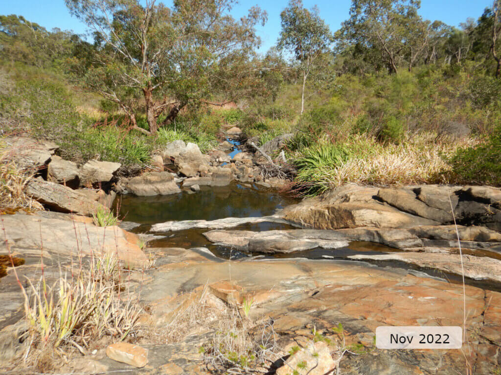
The image below indicates the conditions at the Reserve No 50069 site, on Susannah Brook, in November 2022. November is within the Noongar season of Kambarang (second spring), which is traditionally seen as a transformational time of year with many plants flowering. The season is marked by longer periods of dry weather and rising temperatures. Further images are provided in the gallery at the bottom of the page to show general site conditions, including some from previous assessments.
A summary of site condition over the latest monitoring period is provided in the sections below. For other site data, please contact the department’s River Science team (please reference the site code and sampling dates).
River setting
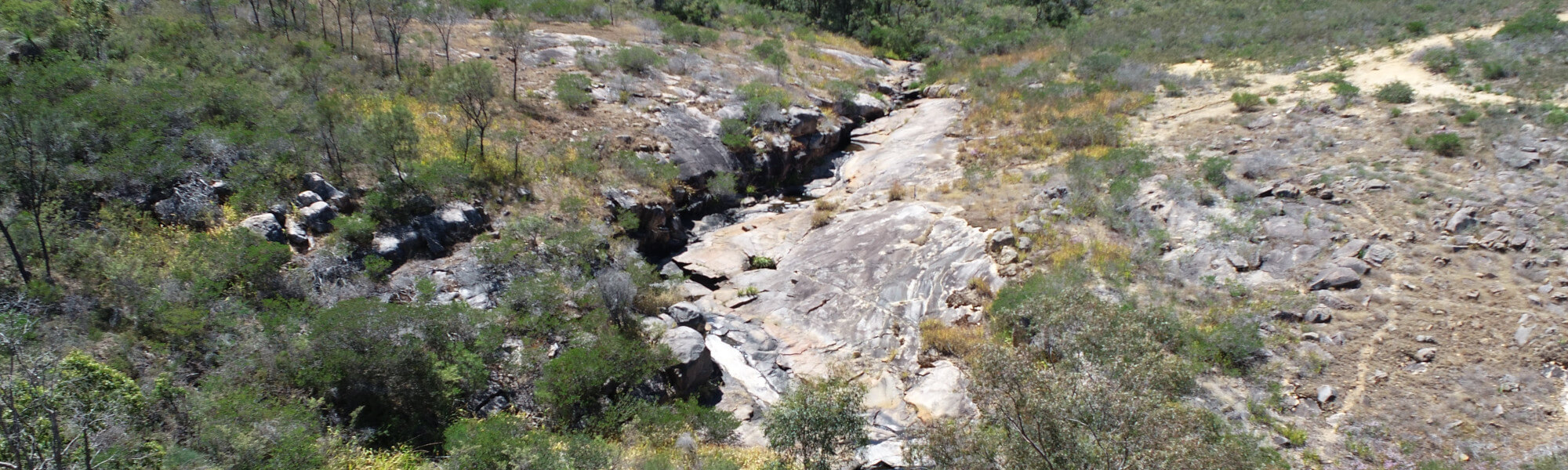
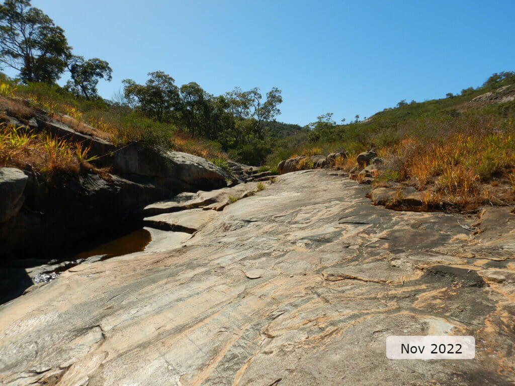
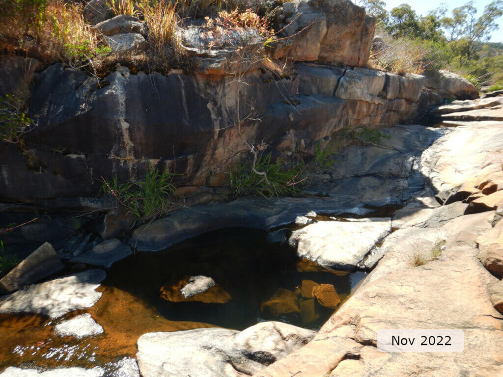
The site is on the Darling Scarp, 25 km north-east of Perth. The assessed section of the brook lies within a steep-sided, V-shaped valley about 3.5 km wide, dominated by remnant vegetation but with large areas of exposed rock and gravelly, lateritic soils. The site was dominated by exposed bedrock with limited riparian vegetation but with some shading provided by a 2–3 m high rock shelf running along the entire length of the right bank. The waterway incorporates a series of eroded rock pools (with evidence of use as gnamma holes), with cascades in between, and no clearly identifiable bank. Further up and downstream the channel is more clearly defined and characterised by multiple layers of riparian vegetation along the banks, providing both shading and habitat with a substrate of cobble, pebble and gravel.
Aquatic habitat
At the time of sampling site habitat diversity was 50 per cent channel (including gnamma holes and bedrock slab), 20 per cent pool and 30 per cent riffle. Over summer and autumn water is only found in the eroded rock pools, which ideally maintain water to provide refuge for aquatic fauna until flow resumes.
The in-stream aquatic habitat was moderately diverse with a range of substrate materials including bedrock, boulders, cobble, pebbles, gravel and sand. Much of the site was bedrock with the majority of the smaller substrate sizes found in the pool at the bottom of the cascade. Woody debris was small (<5 cm diameter) and sparsely distributed throughout the site, yet this limited size range and abundance was natural given the lack of overhanging trees through much of the site.
Overhanging roots and vegetation draped in the water were both limited (<10 per cent of bank length) but the variation in depth in the eroded rock pools (many of which had rocks and boulders within them) provided some habitat diversity, as well as refuge from adverse water temperatures caused by a lack of shading.
Towards the bottom of the site, where there was woody native vegetation in the streamside zone (within 10 m of the banks), tree overhang provided shade across most of the stream width, but in general there was minimal shading from vegetation across the site.
Flow & connectivity
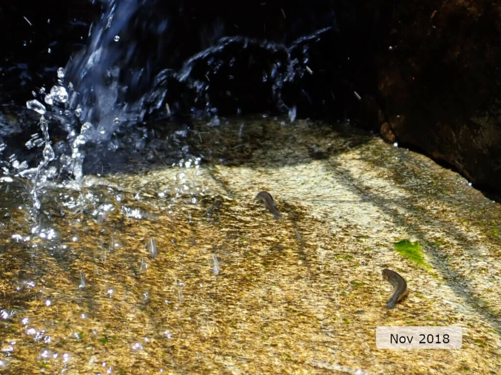
At the time of sampling there was a trickle of flow through the site (see below) but the gradient and physical nature meant the site was impassible for fish. However, western minnows were observed in some rock pools, and at the base of a small fall, still trying to move upstream.
Given the ephemeral flow regime of Susannah Brook and the topography of the site, it is believed that the site would only be connected, in terms of fish passage, during winter and early spring.
Vegetation
The riparian zone (containing species adapted to living at the interface between aquatic and terrestrial environments) was 5–10 m wide on both banks, largely limited by bedrock and natural landform. Through much of the site, the dominance of bedrock meant there was no large woody shading vegetation other than a few small flooded gums (Eucalyptus rudis) around the pool at the bottom of the cascades. Through the majority of the site where bedrock dominated, were scattered shallow-rooted, ground cover plants, with the exotic Watsonia spp. being the dominant species.
There was minimal erosion through the site and the banks had excellent structural integrity. This is because most of the site is on a bedrock slab and those sections of the site with more clearly definable banks were also well vegetated which assists in bank stabilisation.
Water quality
Below is a graph of the water quality recorded during the 24-hour assessment.
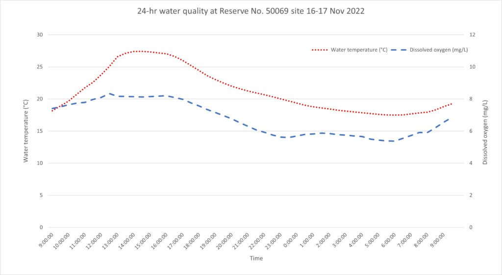
Given the lack of shading, water temperature was suboptimal and exceeded the 25°C threshold1 for 22 per cent of the 24-hr deployment. The diurnal range in water temperature was also suboptimal at 9.93°C, more than twice the ideal range of 4°C or less. In the deeper gnamma holes it is expected that there would be refuge at depth from adverse water temperatures and ranges.
In terms of dissolved oxygen the water quality was optimal as it never fell below the low threshold2 of 4 mg/L and diurnal range was <4 mg/L.
Nutrient concentrations in the water (total nitrogen and total phosphorus) were both classed as low and considered optimal.
Footnote:
1 An upper limit for temperature is nominally set at 25°C based on the range recorded in sites where south-west native fish species are typically found to occur (Beatty et al. 2013).
2 A lower limit of 4 mg/L is taken from the SWIRC where it is used as a guideline limit for condition scoring. This level aligns with Beatty et al. (2013) where south-west native fish species were shown to typically reside in sites with levels above 4 mg/L.
Species found in subcatchment
Native Species
Exotic Species
Species found at the site
Fish and crayfish
The species recorded at Reserve No 50069 in 2022 are provided in table 1 (below). The table includes a list of all species previously reported in the subcatchment, which provides an indication of species that may occur at the assessment site. As differences in habitat within a subcatchment naturally influence species distributions, and variability in methods between sampling programs can affect the species caught, this list is only indicative.
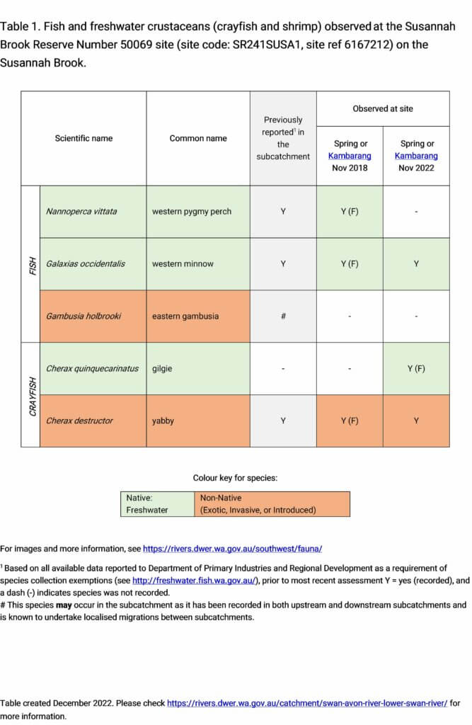
One fish species and two crayfish species were recorded during 2022 sampling. The endemic western minnow was the sole fish species recorded, with the previously observed western pygmy perch (in 2018) not detected during the 2022 assessment. Of the two crayfish species, one was a first record of the endemic gilgie while the other was the previously observed exotic yabby.
While this diversity of aquatic fauna was broadly consistent to that observed during the 2018 assessment, the abundance across all species was greatly reduced. Given the unusual nature of the site, this may because of the timing of sampling and reflects the lack of connectivity through the site and the impact this has on fish passage. Water quality and habitat conditions did not appear to have changed greatly since the 2018 assessment, and western minnow were observed in a pool that were not recorded in traps. This suggests the reduced abundance may not be representative of the aquatic fauna present, but future monitoring will look at timing of sampling and repeat trap setting to assess the site under a greater range of conditions. The image below shows western minnows moving up a wet rock to the base of a small fall in an attempt to move upstream in 2018.
Note: collection of fauna from inland aquatic ecosystems across Western Australia requires a licence from the Department of Primary Industries and Regional Development (DPIRD) and the Department of Biodiversity, Conservation and Attractions (DBCA). All species collected must be reported to these agencies as part of licence conditions.
Other aquatic fauna
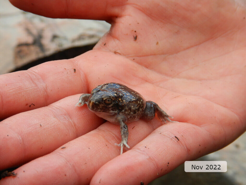
Other fauna observed included a western spotted frog (Heleioporus albopunctatus) and diving beetles.
References & recommended reading


Explore other sites in the catchment
- Bassendean Main Drain Industrial
- Bassendean Main Drain Residential
- Bennett Brook - Downstream of Mussel Pool
- Blackadder Creek - Muriel Street Downstream
- Cookes Brook - Old Coach Road East
- Ellen Brook - Brand Highway downstream
- Ellen Brook - Ellen Brook Nature Reserve
- Ellen Brook - Millhouse Road Bridge
- Helena River - Mundaring Weir Downstream
- Helena River - Whiteman Road
- Jane Brook - De Grey Retreat
- Jane Brook - Sexton Street
- South Belmont Main Drain
- Woodbridge Creek
- Wooroloo Brook - Karls Ranch
- Yalyal Brook