Canning River - Stocker Road
Basin : Swan-Coastal
Catchment : Canning River
River condition at the Stocker Road site on the Canning River (site code: CR41CANN2, site reference: 6167145 ‒ previously reported as site code: STOCK, site reference 6164378) has been assessed on several occasions since 2009. This includes 18 individual fish and crayfish surveys as part of the Healthy Rivers program, including previous versions of the program. Most recently it was assessed three times over the dry season of 2021–22 (during December 2021 and February and May 2022). Additionally, water quality was logged at 30-minute intervals between November 2021 and May 2022.
Healthy Rivers assessments are conducted using standard methods from the South West Index of River Condition (SWIRC), which incorporates field and desktop data from the site and from the broader catchment. Field data collected include the following indicators, assessed over about a 100 m length of stream:
- Aquatic biota: fish and crayfish community information (abundance of native and exotic species across size classes, general reproductive and physical condition)
- Water quality: dissolved oxygen, temperature, specific conductivity, and pH (logged in situ over 24 hours) as well as laboratory samples for colour, alkalinity, turbidity and nutrients
- Aquatic habitat: e.g. water depth, substrate type, presence of woody debris and detritus, type and cover of macrophytes and draping vegetation
- Physical form: channel morphology, bank slope and shape, bioconnectivity (barriers to migration of aquatic species), erosion and sedimentation
- Fringing zone: width and length of vegetation cover within the river corridor and lands immediately adjacent, structural intactness of riparian and streamside vegetation
- Hydrology: measures of flow (velocity) at representative locations (compared against data from stream gauging stations within the system)
- Local land use: descriptions of local land use types and activities (compared against land use mapping information for the catchment)
Previous assessments at this site are listed below and include some or all of the measures above. Note: aquatic fauna sampling methods have been specified given variations between surveys.
| Year | Period | Author | Assessment |
|---|---|---|---|
| 2009–10 | Nov–Apr | Water Science Technical Series, Report no. 35, Department of Water, Government of Western Australia, Perth | 6 x monthly fish and crayfish trapping over 72 hours |
| 2012–13 | Dec–Apr | Department of Water | 3 x bimonthly fish and crayfish trapping over 24 hours |
| 2015–16 | Nov–May | Healthy Rivers (Department of Water) | Full SWIRC assessment (SWIRC method) – Dec 2015 Fish and crayfish trapping only – Feb and Apr 2016 |
| 2018–19 | Nov–Apr | Healthy Rivers (Murdoch University for Department of Water and Environmental Regulation) | Full SWIRC assessment (SWIRC method) – Dec 2018 Fish and crayfish trapping only – Feb and Apr 2019 Mussel survey Dec 2018 and Feb 2019 |
| 2021–22 | Nov–May | Healthy Rivers (Department of Water and Environmental Regulation) | Full SWIRC assessment (SWIRC method) – Dec 2021 Fish and crayfish trapping only – Feb and May 2022 |
For a subset of the assessments above, water quality loggers were deployed for extended periods (see below). This enabled assessment of water quality responses to changes in climate, streamflow and factors such as the intactness of vegetation within the river corridor. Among other things, this allows detection of sub-optimal water quality conditions which can be missed during the standard 24-hour assessment.
- 2015–2016 (Nov–May): Healthy Rivers
- 2018–2019 (Nov–Apr): Healthy Rivers
- 2021–2022 (Nov–May): Healthy Rivers
Other departmental data: The Stocker Road site is about 7.5 km upstream of the Department of Water and Environmental Regulation’s (the department) flow gauging station known as Seaforth (site reference 616027), which has been in operation since 1997.
Search on the site code or site reference in the department’s Water Information Reporting (WIR) system to find data for this site and nearby sampling points (flows, surface water quality, groundwater monitoring, the department's meteorological data). See also the Bureau of Meteorology website for additional meteorological data for the area.
Condition summary
A report from the 2009–10 sampling is available on the department’s website.
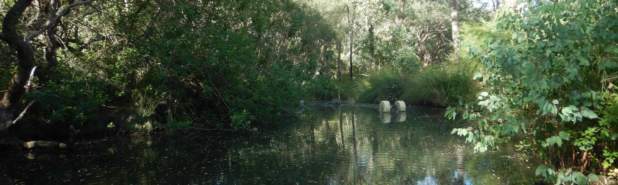
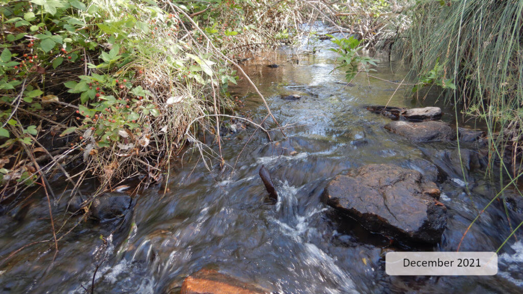
The image below indicates the conditions at the Stocker Road site in December 2021. December is within the Noongar season of Birak (first summer), which is a season marked by decreasing rainfall and increasing temperatures. Further images are provided in the gallery at the bottom of the page to show general site conditions.
A summary of aquatic biota detected over the different sampling events, and water quality over the latest monitoring period, is provided in the sections below. For other site data, please contact the department’s River Science team (please reference the site code and sampling dates).
Flow & connectivity
Scheme water is released from six points along the Canning River over the dry season (about November to May) to maintain key ecological function, provide water for licensed use, and contribute to maintaining the cultural and social values of the river.
These Environmental Water Provisions were formalised in the Middle Canning River surface water allocation plan (2012) and are set out in the Water Resource Management Operating Strategy associated with Water Corporation’s licence for the Integrated Water Supply Scheme. The allocation plan is evaluated and updated as required.
Regarding river health, the release regime was designed to support pool ecology through maintenance of water quality and habitat availability, including providing for localised movement of aquatic fauna. This follows guidance from the Ecological Water Requirements for the Lower Canning River (2010) and has been adapted over time following recommendations from ecological monitoring undertaken as part of the allocation plan evaluation.
Flow data are provided in the next section.
Water quality
Below is a graph of continuous water quality data recorded at Stocker Road between 4 November 2021 and 2 May 2022. Water quality was generally optimal in terms of dissolved oxygen and water temperature. This data is consistent with previous assessments.
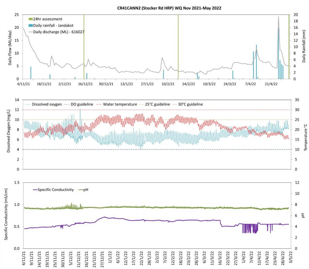
The concentration of dissolved oxygen in the water never fell below the 4 mg/L threshold1. The diurnal range (range over a 24-hour period) was somewhat elevated at times, particularly around late December. Field observations in December noted algae visible in the water column, which likely affected concentrations through photosynthesis (day) and respiration (night).
The upper section of the site, where the water quality loggers were deployed, is deeper and slow-moving (pool habitat). These conditions favour algal growth (over faster flowing waters) through deposition of organic material and nutrients, which feed algae, and stratification and stagnation resulting in higher water temperatures near the surface. Field observation confirmed the accumulation of soft, silty sediment in this area. Additionally, there was limited tree canopy shading along the right bank (which faced north) which would affect localised water temperature and, in turn, dissolved oxygen and algal productivity.
Water temperature over the six-month monitored period exceeded the 25°C threshold2 for 16 per cent of the monitored period but this would have been offset by the fact that aquatic fauna had access to refuge from these higher temperatures in deeper, cooler water just upstream of the water quality logger.
Specific conductivity and pH remained within acceptable ranges, based on expectations of natural ranges for freshwater rivers of south-west Western Australia.
Footnote:
1 A lower limit of 4 mg/L is taken from the SWIRC where it is used as a guideline limit for condition scoring. This level aligns with Beatty et al. (2013) where south-west native fish species were shown to typically reside in sites with levels above 4 mg/L.
2 An upper limit for temperature is nominally set at 25°C based on the range recorded in sites where south-west native fish species are typically found to occur (Beatty et al. 2013).
Species found in subcatchment
Native Species
- Carter's freshwater musselWestralunio carteri
- Freshwater cobblerTandanus bostocki
- Frogsover 30 southwest species
- GilgieCherax quinquecarinatus
- NightfishBostockia porosa
- Rakali - water ratHydromys chrysogaster
- Smooth marronCherax cainii
- South-west glass shrimpPalaemon australis
- South-western snake-necked turtleChelodina colliei
- Western minnowGalaxias occidentalis
- Western pygmy perchNannoperca vittata
Species found at the site
Fish and crayfish
The species captured at the Stocker Road site during each of the sampling periods since 2009–10 are provided in Table 2. The table includes a list of all species previously reported in the subcatchment, which provides an indication of species that may occur at the assessment site. As differences in habitat within a subcatchment naturally influence species distributions, and variability in methods between sampling programs can affect the species caught, this list is only indicative.
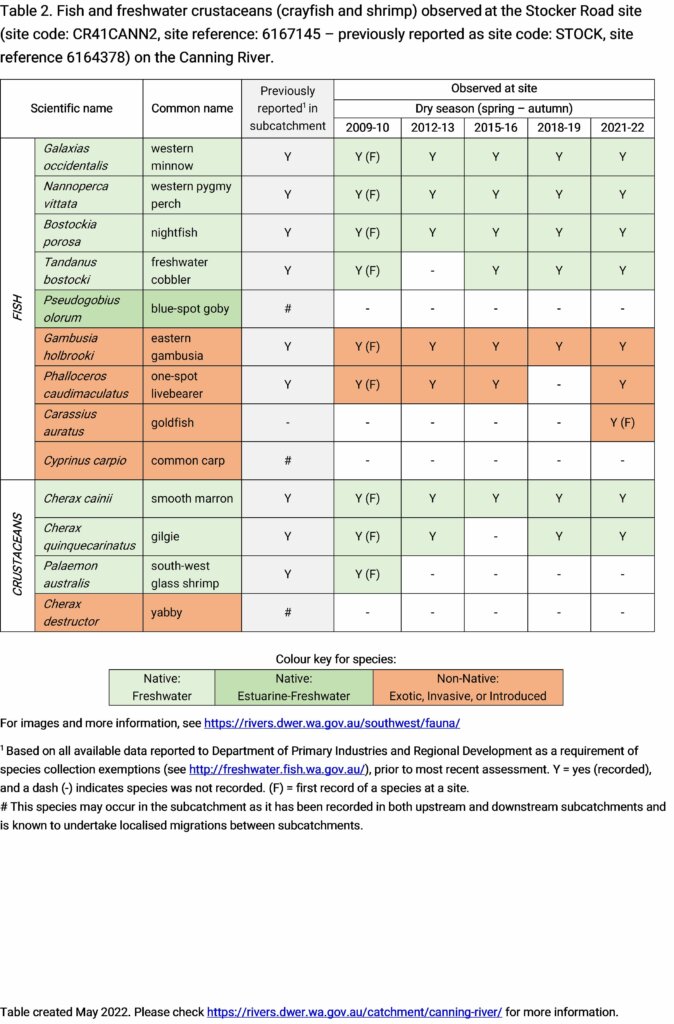
Seven species of fish and two species of crustacean were recorded during the 2021–22 sampling. This included four native, endemic fish species (freshwater cobbler, western minnow, western pygmy perch and nightfish) and two endemic freshwater crayfish (smooth marron and gilgie). Three exotic fish species were also recorded including eastern gambusia and one-spot livebearer. Exotic goldfish were recorded for the first time at this site during 2021–22; two large individuals were also observed, but not caught (see image in gallery).
During the 2021–22 assessments both western minnow and western pygmy perch were relatively abundant while nightfish were less abundant. Juveniles were recorded for all three species indicating a healthy system where conditions are met for these species to breed.
The large-bodied native freshwater cobbler was present but not abundant and no juveniles were recorded. It is worth noting that all cobbler (four) were caught in the upstream-facing net during two of the three fish surveys in 2021–22. This suggests a population in, or upstream of, the pool at the upper end of the site. Those observations along with the large size of cobbler (relative to all other native fish) and requirement for movement within the system through the dry season provides a good indication that bioconnectivity is being maintained.
Both of the commonly found crayfish species (smooth marron and gilgie) were abundant in 2021–22 but juveniles were only recorded for gilgies.
Of the exotic fish, eastern gambusia was the most abundant and with the most juveniles. Both one-spot livebearer and goldfish were less abundant and with very low numbers of juveniles. 2021–22 was the first time was the first time that goldfish have been caught at this site. The presence of large goldfish suggests they have either been recently introduced to the area or a population has existed but not been detected until the 2021–22 assessments.
Note: collection of fauna from inland aquatic ecosystems across Western Australia requires a licence from the Department of Primary Industries and Regional Development (DPIRD) and the Department of Biodiversity, Conservation and Attractions (DBCA). All species collected must be reported to these agencies as part of licence conditions.
Other aquatic fauna
Carter’s freshwater mussel (Westralunio carteri) was observed at the Stocker Road site during the 2021–22 assessments. This mollusc is the sole endemic freshwater mussel species in Western Australia and currently listed as vulnerable on the International Union for Conservation of Nature’s (IUCN) red list of threatened species (because of declining range, which is largely attributed to the effects of salinity).
Although not targeted by collection methods, south-western snake-necked turtles (Chelodina oblonga) and unknown species of frog or tadpoles (Anura) were collected in fish nets and/or traps.
Evidence of rakali (Hydromys chrysogaster) activity was also recorded (holes in nets, chewed floats and ropes and neatly incised and consumed crayfish tails). This species is listed by DBCA as a Priority 4 species (rare, near threatened and other species in need of monitoring).
For more information on these and other aquatic species, please see the River Science fauna page.
References & recommended reading


Explore other sites in the catchment
- 31 Mile Creek
- Bannister Creek - Bywood Way
- Bannister Creek - Upstream Hybanthus Road
- Bannister Creek - Upstream Iveston Road
- Bannister Creek - Upstream Metcalf Road
- Bickley Brook - Canning River confluence
- Bickley Brook - Davison Road
- Bickley Brook - Eva Street Downstream
- Bickley Brook - Eva Street Upstream
- Bickley Brook - Kenwick Link
- Bickley Brook - Mandarin Road
- Bickley Brook - Upstream BICKBK01A
- Bickley Brook - Upstream Mandarin Road
- Bull Creek - Upstream Corthinian Road
- Canning River - Brookton Highway
- Canning River - Civic Gardens
- Canning River - Corner Pool
- Canning River - Hester Park
- Canning River - Kent St Weir Downstream
- Canning River - Kent St Weir Upstream
- Canning River - Lissiman Street
- Canning River - McNess Drive
- Canning River - Odell Street
- Canning River - Powerline Pool
- Canning River - Seaforth
- Canning River - Tributary
- Mill Street Main Drain - Palm Place
- Southern River
- Southern River - Shearwater Way
- Woodlupine Brook Branch Drain
- Wungong Brook - Bruns Drive
- Wungong Brook - South Western Highway
- Wungong River - Wattledale Road
- Wungong River - WUNGRIV01
- Wungong River - WUNGRIV01A
- Wungong River - WUNGRIV05
- Wungong River - WUNGRIV05A
- Yule Brook