Wungong River - Wattledale Road
Basin : Swan-Coastal
Catchment : Canning River
The condition of the Wungong River - Wattledale Road (site code: CR35SOUT1, site reference: 6167148) was assessed between 14–15 November 2022.
Healthy Rivers assessments are conducted using standard methods from the South West Index of River Condition (SWIRC), which incorporates field and desktop data from the site and from the broader catchment. Field data collected include the following indicators, assessed over about a 100 m length of stream:
- Aquatic biota: fish and crayfish community information (abundance of native and exotic species across size classes, general reproductive and physical condition)
- Water quality: dissolved oxygen, temperature, specific conductivity, and pH (logged in situ over 24 hours) as well as laboratory samples for colour, alkalinity, turbidity and nutrients
- Aquatic habitat: e.g. water depth, substrate type, presence of woody debris and detritus, type and cover of macrophytes and draping vegetation
- Physical form: channel morphology, bank slope and shape, bioconnectivity (barriers to migration of aquatic species), erosion and sedimentation
- Fringing zone: width and length of vegetation cover within the river corridor and lands immediately adjacent, structural intactness of riparian and streamside vegetation
- Hydrology: measures of flow (velocity) at representative locations (compared against data from stream gauging stations within the system)
- Local land use: descriptions of local land use types and activities (compared against land use mapping information for the catchment)
The site was previously assessed during January 2019. The only obvious difference in conditions between this spring sampling and the previous (2019) summer sampling was the Colocasia spp. (elephant ear or taro) was less developed in spring than during summer. This allowed a more comprehensive assessment of the complex wetland nature of the right bank, which was not as apparent in 2019 when it was largely obscured by the dense stands of taro.
Other departmental data: The Wattledale Road site is about 10 km upstream of the Department of Water and Environmental Regulation’s (the department) flow gauging station known as Anaconda Drive (site ref 616092), which has been in operation since 1990.
Search the site code or site reference in the department’s Water Information Reporting (WIR) system to find data for this site and nearby sampling points (flows, surface water quality, groundwater monitoring, the department's meteorological data). See also the Bureau of Meteorology website for additional meteorological data for the area.
Condition summary
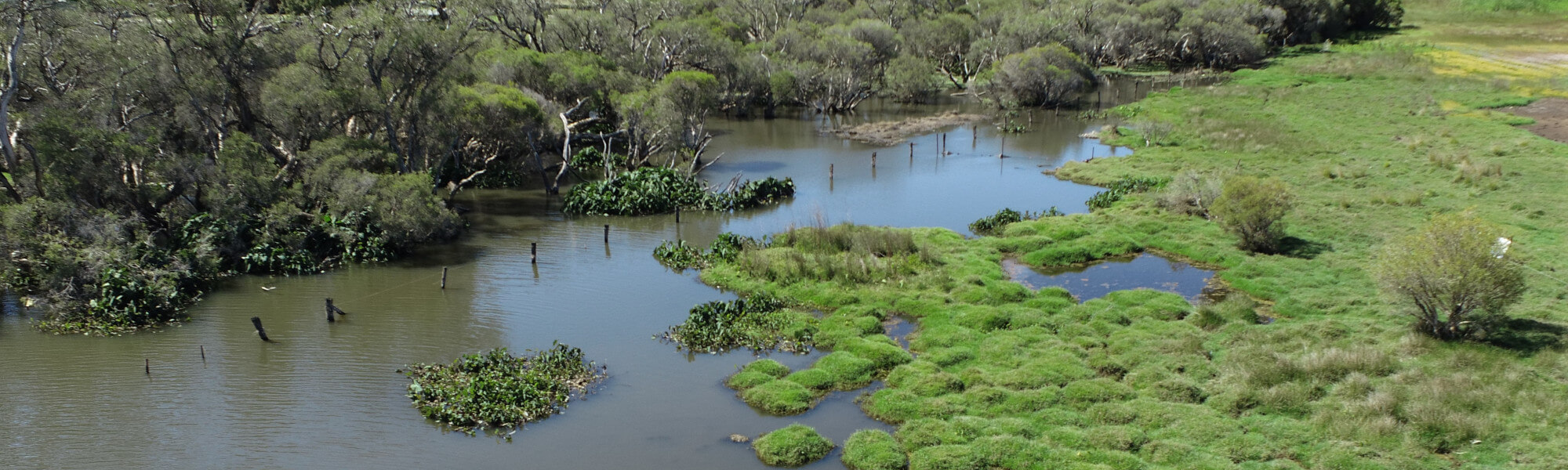
The image below indicates the conditions at the Wattledale Road site in November 2022. November is within the Noongar season of Kambarang (second spring), which is traditionally seen as a transformational time of year with many plants flowering. The season is marked by longer periods of dry weather and rising temperatures. Further images are provided in the gallery at the bottom of the page to show general site conditions, including some from previous assessments.
A summary of site condition over the latest monitoring period is provided in the sections below. For other site data, please contact the department’s River Science team (please reference the site code and sampling dates).
River setting
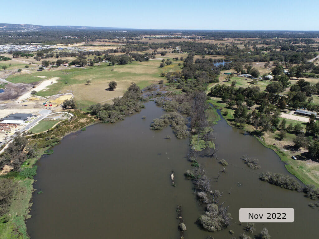
The Wattledale Road site is on the Wungong River (which becomes Southern River further downstream), a major tributary of the Canning River on the Swan Coastal Plain, about 30 km south of Perth.
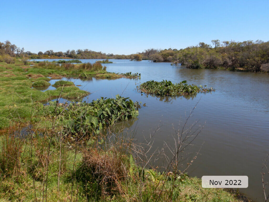
The site lies within a peri-rural area on the urban fringe. Urban infill is expanding in the area and has encroached close to the river on the right bank (see left of image below).
At the time of sampling, the site was at the downstream end of a very wide (up to 70 m) section of channel within a broad meandering plane-bed channel. The site was in a low-gradient section of the river, typical of the Swan Coastal Plain. The banks were low-sloped, and along the right bank the margins of the channel were characterised by a complex wetland habitat which extended for 20–30 m past the ‘apparent’ banks at the time of sampling.
Aquatic habitat
The site was classed as channel habitat, but the flow was very slow moving to stationary (pool-like). The channel was moderately varied, between 1–2 m deep and between 40–80 m wide.
The aquatic habitat was suboptimal as there was very little variation in substrate type (silt), limited diversity (small pieces, <5 cm diameter) and abundance of woody debris, and limited shading on the banks – although in-stream stands of paperbarks provided mid-channel shading. Habitat from overhanging roots and banks was minimal but bank vegetation draped in the water was extensive, mostly by exotic grasses and Colocasia spp. (elephant ear or taro). In-stream aquatic vegetation covered around 15 per cent of the site and was dominated by taro, which was mostly found on the right bank and under the mid-channel stand of paperbarks.
Tree canopy shading was mixed with a dense stand of Melaleuca spp. (paperbarks) in the channel towards the left bank. The right bank only had trees providing shading near the upstream end of the site, where paperbarks grew across the whole channel (about 20 m wide).
Flow & connectivity
At the time of sampling the site was essentially a stationary, shallow lake with fringing wetland habitat. The site was connected in terms of fish passage within the site and to the wider system as evidenced by the presence of the large-bodied, native freshwater cobbler.
Vegetation
The riparian zone (containing species adapted to living at the interface between aquatic and terrestrial environments) was severely limited on the left bank (5 m) and of optimal width (50 m) on the right bank but in suboptimal condition (cleared and weed dominated). All vegetation layers were reduced by human impact, historically by clearing for agriculture, which has not been addressed (through revegetation efforts) as land uses have been reclassified to allow increasing peri-urban and urban development.
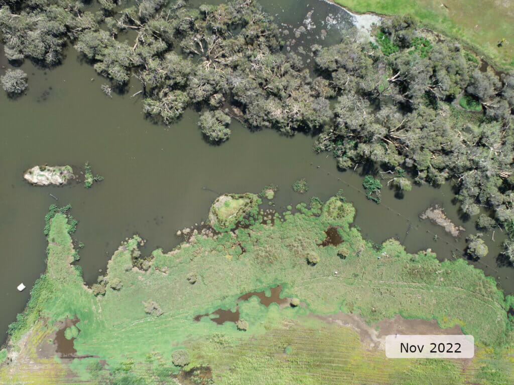
The site was unusual in that the highest value vegetation was found in the channel rather than on the banks (see image above). These paperbarks provided the only stream shading (as both banks were largely treeless), as well as being the main source of the little woody debris that was observed.
The shrub layer was greatly reduced to a few scattered Melaleuca spp. (teatrees) observed on the right bank. There was limited, natural recruitment of native woody vegetation (trees) and it was in moderate health. The ground cover layer was largely exotic (dominated by grasses and taro) but with a few native rushes scattered through the complex wetland habitat along the right bank.
There was minimal erosion (both severity and extent), and the banks were assessed as having excellent structural integrity. This is unsurprising given the naturally flat banks, particularly through the wetland habitat on the right bank. A flat bank has a lower risk of erosion as, even in high-flow conditions, the water simply spreads out to occupy the available space.
Water quality
Below is a graph of the water quality recorded during the 24-hour assessment.
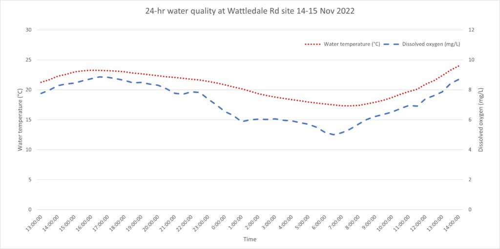
Water quality was mixed. The water temperature remained below the 25°C threshold,1 which is optimal, but the diurnal range was >6.5°C. Anything greater than a 4°C diurnal range is considered suboptimal. This range in water temperature was recorded with the logger placed in shade to present a best case scenario for the site.
Dissolved oxygen was optimal as it remained above the 4 mg/L threshold.2 The diurnal range was greater than expected (about 3.8 mg/L) given the time of year sampling was conducted. It suggests there are some biological influences (algal photosynthesis and respiration) driving the dissolved oxygen at the site. It is reasonable to assume that during summer and autumn greater algal activity will exert a greater influence on dissolved oxygen, resulting in suboptimal conditions. These sub-optimal water quality conditions are likely to favour exotic species of aquatic fauna as they tolerate these conditions better than our native species.
Nutrient concentrations in the water (total nitrogen and total phosphorus) were moderate, likely reflecting some impacts from land uses in the catchment. Specific conductivity (which can be used as an indicator of salinity) was marginal and pH was optimal, based on expectations of natural ranges for freshwater rivers of south-west Western Australia.
Footnote:
1 An upper limit for temperature is nominally set at 25°C based on the range recorded in sites where south-west native fish species are typically found to occur (Beatty et al. 2013).
2 A lower limit of 4 mg/L is taken from the SWIRC where it is used as a guideline limit for condition scoring. This level aligns with Beatty et al. (2013) where south-west native fish species were shown to typically reside in sites with levels above 4 mg/L.
Species found in subcatchment
Native Species
Species found at the site
Fish and crayfish
The species recorded at Wattledale Road in 2022 are provided in table 1 below. The table includes a list of all species previously reported in the subcatchment, which provides an indication of species that may occur at the assessment site. As differences in habitat within a subcatchment naturally influence species distributions, and variability in methods between sampling programs can affect the species caught, this list is only indicative.
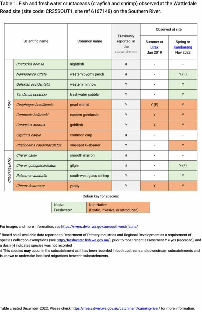
Seven fish species and three crustacean species were recorded in 2022. This included three native freshwater fish (western minnow, freshwater cobbler and western pygmy perch) and two native freshwater crustaceans (gilgie and south-west glass shrimp). 2022 was the first time both the western pygmy perch and gilgie had been recorded at this site. Four exotic species of fish were also recorded.
There was a marked increase in the diversity of native fish species between the 2019 and 2022 assessments. In 2019 no native fish or crustaceans were recorded but in 2022 five were observed, including two for the first time at the site. This suggests the ‘absence’ of native species in 2019 was likely a result of sampling effort (meaning the species were present but were not detected). Alternatively, it could reflect natural variations in distribution within the reach ‒ such as seasonal migrations of fish within the reach ‒ or the wider river system.
All four previously observed exotic species in 2019 were detected again in 2022 (pearl cichlid, eastern gambusia, goldfish and yabby). In addition the one-spot livebearer was also recorded which, although expected, was not observed during the 2019 assessment.
While the diversity of native species was improved, the continued presence of exotics and the suboptimal conditions at the site present an ongoing risk to the native fish and crustacean populations. Overall abundance was about one quarter of that recorded in 2019, although this can be largely attributed to the reduced catch of exotic eastern gambusia. That said, the number of gambusia is not expected to have declined as several large schools were observed but were not represented in the 2022 assessment.
Note: collection of fauna from inland aquatic ecosystems across Western Australia requires a licence from the Department of Primary Industries and Regional Development (DPIRD) and the Department of Biodiversity, Conservation and Attractions (DBCA). All species collected must be reported to these agencies as part of licence conditions.
Other aquatic fauna
Although not targeted by collection methods, the south-western snake-necked turtle (Chelodina oblonga) was recorded at the Wattledale Road site in 2022.
References & recommended reading


Explore other sites in the catchment
- 31 Mile Creek
- Bannister Creek - Bywood Way
- Bannister Creek - Upstream Hybanthus Road
- Bannister Creek - Upstream Iveston Road
- Bannister Creek - Upstream Metcalf Road
- Bickley Brook - Canning River confluence
- Bickley Brook - Davison Road
- Bickley Brook - Eva Street Downstream
- Bickley Brook - Eva Street Upstream
- Bickley Brook - Kenwick Link
- Bickley Brook - Mandarin Road
- Bickley Brook - Upstream BICKBK01A
- Bickley Brook - Upstream Mandarin Road
- Bull Creek - Upstream Corthinian Road
- Canning River - Brookton Highway
- Canning River - Civic Gardens
- Canning River - Corner Pool
- Canning River - Hester Park
- Canning River - Kent St Weir Downstream
- Canning River - Kent St Weir Upstream
- Canning River - Lissiman Street
- Canning River - McNess Drive
- Canning River - Odell Street
- Canning River - Powerline Pool
- Canning River - Seaforth
- Canning River - Stocker Road
- Canning River - Tributary
- Mill Street Main Drain - Palm Place
- Southern River
- Southern River - Shearwater Way
- Woodlupine Brook Branch Drain
- Wungong Brook - Bruns Drive
- Wungong Brook - South Western Highway
- Wungong River - WUNGRIV01
- Wungong River - WUNGRIV01A
- Wungong River - WUNGRIV05
- Wungong River - WUNGRIV05A
- Yule Brook