Wooroloo Brook - Karls Ranch
Basin : Swan-Coastal
Catchment : Swan-Avon River - Lower Swan River
River condition at the Karl's Ranch site on Wooroloo Brook (site code: SR308WOOR1, site reference: 6167211) was assessed between 16–17 November 2022.
Healthy Rivers assessments are conducted using standard methods from the South West Index of River Condition (SWIRC), which incorporates field and desktop data from the site and from the broader catchment. Field data collected include the following indicators, assessed over about a 100 m length of stream:
- Aquatic biota: fish and crayfish community information (abundance of native and exotic species across size classes, general reproductive and physical condition)
- Water quality: dissolved oxygen, temperature, specific conductivity, and pH (logged in situ over 24 hours) as well as laboratory samples for colour, alkalinity, turbidity and nutrients
- Aquatic habitat: e.g. water depth, substrate type, presence of woody debris and detritus, type and cover of macrophytes and draping vegetation
- Physical form: channel morphology, bank slope and shape, bioconnectivity (barriers to migration of aquatic species), erosion and sedimentation
- Fringing zone: width and length of vegetation cover within the river corridor and lands immediately adjacent, structural intactness of riparian and streamside vegetation
- Hydrology: measures of flow (velocity) at representative locations (compared against data from stream gauging stations within the system)
- Local land use: descriptions of local land use types and activities (compared against land use mapping information for the catchment)
The site was previously assessed during November 2018.
In addition to methods summarised above, a water quality logger was deployed for an extended period from November 2022 to May 2023. This enabled assessment of water quality responses to changes in climate, streamflow and factors such as the intactness of vegetation within the river corridor. Among other things, this allows detection of suboptimal water quality conditions which can be missed during the standard 24-hour assessment.
Other departmental data: The Karl's Ranch site is located at the Department of Water and Environmental Regulation’s (the department) flow gauging station known as Karl's Ranch (site reference 616001), which has been in operation since 1962.
Search the site code or site reference in the department’s Water Information Reporting (WIR) system to find data for this site and nearby sampling points (flows, surface water quality, groundwater monitoring, the department's meteorological data). See also the Bureau of Meteorology website for additional meteorological data for the area.
Condition summary
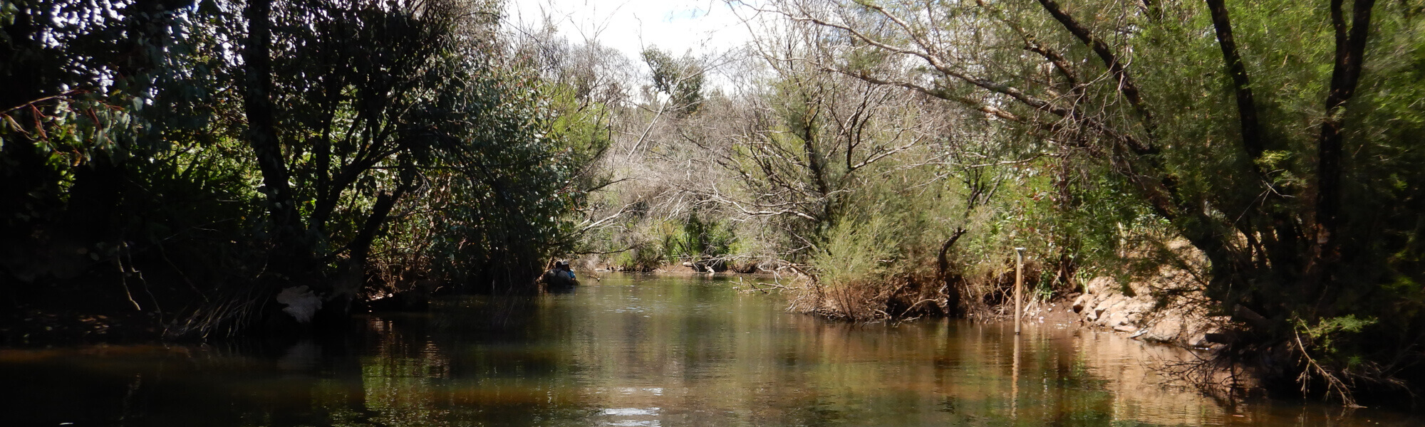
The image below indicates the conditions at the Karl’s Ranch site in November 2022. November is within the Noongar season of Kambarang (second spring), which is traditionally seen as a transformational time of year with many plants flowering. The season is marked by longer periods of dry weather and rising temperatures. Further images are provided in the gallery at the bottom of the page to show general site conditions, including some from previous assessments.
A summary of site condition over the latest monitoring period is provided in the sections below. For other site data, please contact the department’s River Science team (please reference the site code and sampling dates).
River setting
The Karl’s Ranch HRP site is on Wooroloo Brook in the Darling Scarp about 40 km north east of Perth.
The site lies within a steep-sided, V-shaped valley about 7.5 km wide, with the dominant rocky geology and topography largely dictating the channel position. The site contains two contrasting habitat types, with a low-gradient section, characterised by a deeper, slow-flowing channel/pool upstream. Below the gauging weir, the gradient is steeper, with shallow, rocky cascades and riffles as the brook begins to flow down the scarp toward the Avon Valley.
Aquatic habitat
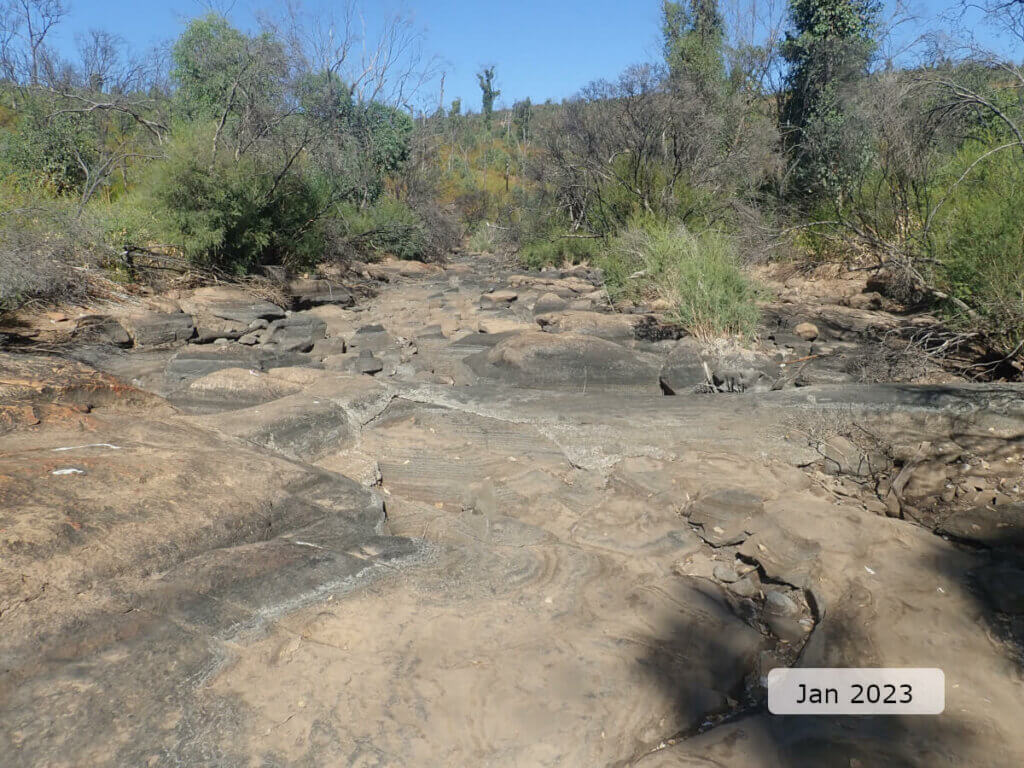
At the time of sampling, the habitat diversity through the site was classed as 40 per cent channel, 40 per cent pool and 20 per cent riffle. During summer and autumn the site consisted of two small, isolated pools and much of the site was dry. The in-stream aquatic habitat was moderately diverse, offering a range of niches to aquatic fauna. There was a range of substrate materials including bedrock, boulders, cobble, pebbles, gravel and sand. Woody debris of the 2–3 smaller sizes was moderately abundant throughout the site (the largest size class of ≥50 cm diameter was absent). The amount of in-stream woody debris was noticeably less than recorded during the 2018 assessment, presumably because of the effects of the February 2021 bushfire. Overhanging roots, overhanging banks and bank vegetation draped in the water each provided habitat along up to half of the bank lengths. Water depth was varied (between 25 cm to >2 m), and water width was an average of 9 m.
Streamside vegetation (within the first 10 m from either bank) provided shading along the majority of the banks (85–90 per cent), with shading extending an average of 2 m over the brook from the banks. In 2018 the shading from vegetation extended for an average of 4 m from the banks, illustrating secondary detrimental effects of the 2021 bushfires on the vegetation and, in turn stream shading.
Flow & connectivity
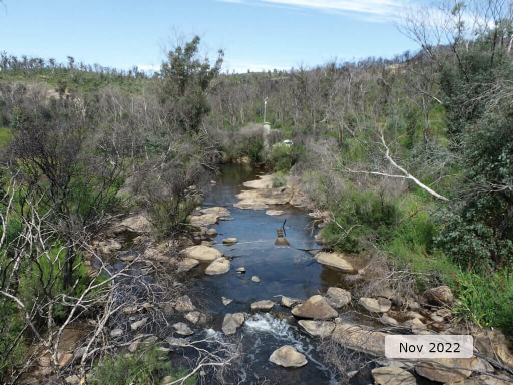
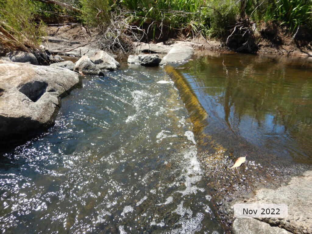
Wooroloo Brook is an intermittent system which flows in response to winter rains and into spring before contracting to isolated pools during summer and autumn. At the time of sampling the site was connected and flowing, but flow ceased by the end of December 2022. Located within the site is the flow control structure or weir (see image below) for the department’s flow gauging station 616001 (Karl’s Ranch). This structure would present an obstacle to fish under low-flow conditions but is likely not an impassable structure for most of the period during which the wider system is connected.
While the weir may slightly increase the period of disconnection for fish passage, it is not likely to be a significant barrier, especially when considering the steep, cascade and riffle-like nature of the site downstream of the weir which dries completely during summer and autumn (see below). Note: the weir runs from centre of the image to the right.
Vegetation
The riparian zone (containing species adapted to living at the interface between aquatic and terrestrial environments) was 15–20 m wide on both banks.
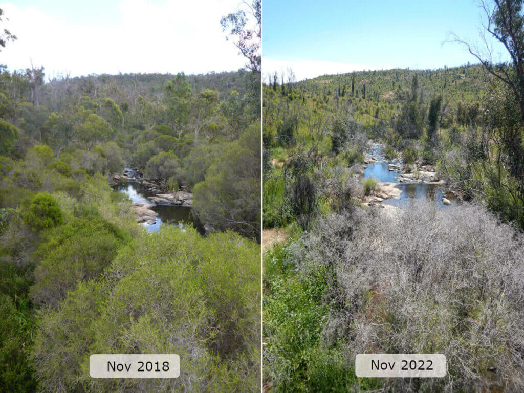
Streamside zone vegetation cover was unsurprisingly reduced in the shrub and tree layer (post-fire), with many trees still only having epicormic growth of leaves and the branches remained bare or absent. Dominant trees species included Eucalyptus rudis (flooded gum) with some Melaleuca rhaphiophylla (swamp paperbark). Native woody vegetation recruitment was also reduced from ‘healthy and abundant’ in 2018 to ‘moderate’ in 2022. The ground layer cover had increased since 2018, as many of these plants would recolonise more quickly than woody shrubs and trees. The exotic weed Watsonia spp. (bugle lily) was noticeably more widespread in the ground cover layer, this is likely because it quickly recovered post-fire from its corms, and then rapidly spread in the newly cleared landscape.
More than half of the total bank length over the 100 m site was affected by erosion. Severity of erosion was low to moderate, meaning the banks had a good level of structural integrity with little chance of significant change in channel depth or shape in the future. This was largely because of tree and shrub roots supporting the banks.
Water quality
Below is a graph of the continuous water quality recorded at Karl’s Ranch from November 2022 to May 2023. This was the first long-term water quality recorded at this site.
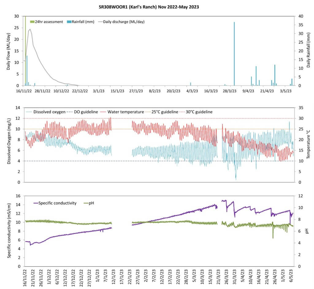
Water temperature was suboptimal as it was above the 25°C threshold1 for one-quarter (24 per cent) of the deployment period. The diurnal water temperature range was also suboptimal (>4°C) for large parts the monitored period. This suggests a lack of shading, and reduced tree shading is evident after the February 2021 bushfire (see image in vegetation section).
Dissolved oxygen was near-optimal and was below the 4 mg/L threshold2 for 5 per cent of the monitored period, and below the very low threshold of 2 mg/L for 0.35 per cent of the monitored period. The diurnal dissolved oxygen range was less optimal for periods when the pool the logger was in contracted to its smallest extent (mostly late February to April 2023). Under these conditions, biological drivers (e.g. algae) had a greater effect on dissolved oxygen through photosynthesis (day) and respiration (night), in the small, static pool that remained.
Specific conductivity (which can be used as an indicator of salinity) was suboptimal, based on expectations of natural ranges for freshwater rivers of south-west Western Australia. Specific conductivity steadily increased from a ‘mid-saline’ classification in November 2022 to a peak of ‘high-saline’ classification in late March 2023. The conductivity then fell in steps in response to rain events in April 2023. Wooroloo Brook is affected by secondary salinity because of clearing of deep-rooted vegetation, particularly in the upper catchment, resulting in the generally higher salinities recorded. The pattern observed in the specific conductivity plot of increasing salinity is largely because of declining surface flows and ground water expression becoming dominant as water levels contract to isolated pools, since the ground water is more saline than winter-rain-driven, surface flows.
pH was largely within acceptable ranges, based on expectations of natural ranges for freshwater rivers of south-west Western Australia. The diurnal range increased towards the end of the logger deployment and this, like the increased diurnal dissolved oxygen range, is likely because of algal activity in the small pool, as the chemical by by-products of photosynthesis and respiration affect the pH.
Nutrient concentrations in the water (total nitrogen and total phosphorus) were both classed as low and considered optimal.
Footnote:
1 An upper limit for temperature is nominally set at 25°C based on the range recorded in sites where south-west native fish species are typically found to occur (Beatty et al. 2013).
2 A lower limit of 4 mg/L is taken from the SWIRC where it is used as a guideline limit for condition scoring. This level aligns with Beatty et al. (2013) where south-west native fish species were shown to typically reside in sites with levels above 4 mg/L.
Species found in subcatchment
Native Species
- Carter's freshwater musselWestralunio carteri
- Freshwater cobblerTandanus bostocki
- GilgieCherax quinquecarinatus
- NightfishBostockia porosa
- Smooth marronCherax cainii
- South-west glass shrimpPalaemon australis
- South-western snake-necked turtleChelodina colliei
- Western minnowGalaxias occidentalis
- Western pygmy perchNannoperca vittata
Exotic Species
Species found at the site
Fish and crayfish
The species recorded at Karl’s Ranch in 2022 are provided in Table 1 below. The table includes a list of all species previously reported in the subcatchment, which provides an indication of species that may occur at the assessment site. As differences in habitat within a subcatchment naturally influence species distributions, and variability in methods between sampling programs can affect the species caught, this list is only indicative.
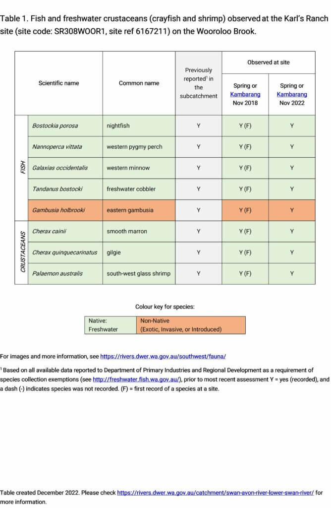
Five species of fish and three species of crustaceans were recorded during the 2022 sampling. This included four native fish species (western minnow, western pygmy perch, freshwater cobbler and nightfish) and three native freshwater crayfish/crustaceans (smooth marron, gilgie and south-west glass shrimp).
Freshwater cobbler abundance was low but almost all individuals recorded were juveniles, indicating a sufficiently healthy system where conditions are met for the species to breed. Those observations along with large size of cobbler (relative to all other native fish) and requirement for movement within the system provides a good indication that bioconnectivity is being maintained.
The only exotic fish species recorded was the eastern gambusia. Abundance was low and no juveniles were recorded which is encouraging as it suggests the population may not be well established, which would present less risk to native fish populations.
This diversity of aquatic fauna was consistent to that observed during the 2018 SWIRC assessment, though abundance was around 50 per cent lower. This may be a result of less favourable conditions, resulting from the effects of the bushfire on streamside vegetation and shading, or may simply be natural variability in catches because of normal species movements or seasonal migrations through the site.
Note: collection of fauna from inland aquatic ecosystems across Western Australia requires a licence from the Department of Primary Industries and Regional Development (DPIRD) and the Department of Biodiversity, Conservation and Attractions (DBCA). All species collected must be reported to these agencies as part of licence conditions.
Other aquatic fauna
No other aquatic fauna were observed in 2022. South-western snake-necked turtle (Chelodina oblonga) and juvenile Carter’s freshwater mussel (Westralunio carteri) were both recorded in 2018.
Carter’s freshwater mussel is the sole endemic freshwater mussel species in Western Australia and currently listed as vulnerable on the International Union for Conservation of Nature’s (IUCN) red list of threatened species (because of declining range, which is largely attributed to the effects of salinity). The juvenile mussels observed in 2018 are thought to have come from fresher tributaries of the brook, as has been documented in the Kent River system in Western Australia (see Benson et al. 2019), but the Karl’s Ranch site is too saline for populations to become established.
For more information on these and other aquatic species, please see the River Science fauna page.
References & recommended reading


Explore other sites in the catchment
- Bassendean Main Drain Industrial
- Bassendean Main Drain Residential
- Bennett Brook - Downstream of Mussel Pool
- Blackadder Creek - Muriel Street Downstream
- Cookes Brook - Old Coach Road East
- Ellen Brook - Brand Highway downstream
- Ellen Brook - Ellen Brook Nature Reserve
- Ellen Brook - Millhouse Road Bridge
- Helena River - Mundaring Weir Downstream
- Helena River - Whiteman Road
- Jane Brook - De Grey Retreat
- Jane Brook - Sexton Street
- South Belmont Main Drain
- Susannah Brook - Reserve No 50069
- Woodbridge Creek
- Yalyal Brook