Southern River - Shearwater Way
Basin : Swan-Coastal
Catchment : Canning River
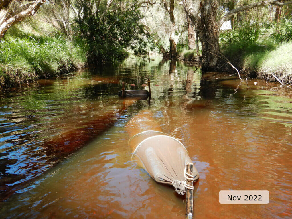
The condition of the Southern River - Shearwater Way (site code: CR13SOUT1, site reference: 6167147), was assessed between 14–15 November 2022.
Healthy Rivers assessments are conducted using standard methods from the South West Index of River Condition (SWIRC), which incorporates field and desktop data from the site and from the broader catchment. Field data collected include the following indicators, assessed over about a 100 m length of stream:
- Aquatic biota: fish and crayfish community information (abundance of native and exotic species across size classes, general reproductive and physical condition)
- Water quality: dissolved oxygen, temperature, specific conductivity, and pH (logged in-situ over 24 hours) as well as laboratory samples for colour, alkalinity, turbidity and nutrients
- Aquatic habitat: e.g. water depth, substrate type, presence of woody debris and detritus, type and cover of macrophytes and draping vegetation
- Physical form: channel morphology, bank slope and shape, bioconnectivity (barriers to migration of aquatic species), erosion and sedimentation
- Fringing zone: width and length of vegetation cover within the river corridor and lands immediately adjacent, structural intactness of riparian and streamside vegetation
- Hydrology: measures of flow (velocity) at representative locations (compared against data from stream gauging stations within the system)
- Local land use: descriptions of local land use types and activities (compared against land use mapping information for the catchment)
The site was previously assessed during January 2019. There was no obvious difference in water level between this spring assessment and the previous (2019) summer assessment (see flow and connectivity section).
Other departmental data: The Shearwater Way site is about 900 m upstream of the Department of Water and Environmental Regulation’s (the department) flow gauging station known as Anaconda Drive (site reference 616092), which has been in operation since 1990.
Search the site code or site reference in the department’s Water Information Reporting (WIR) system to find data for this site and nearby sampling points (flows, surface water quality, groundwater monitoring, the department's meteorological data). See also the Bureau of Meteorology website for additional meteorological data for the area.
Condition summary
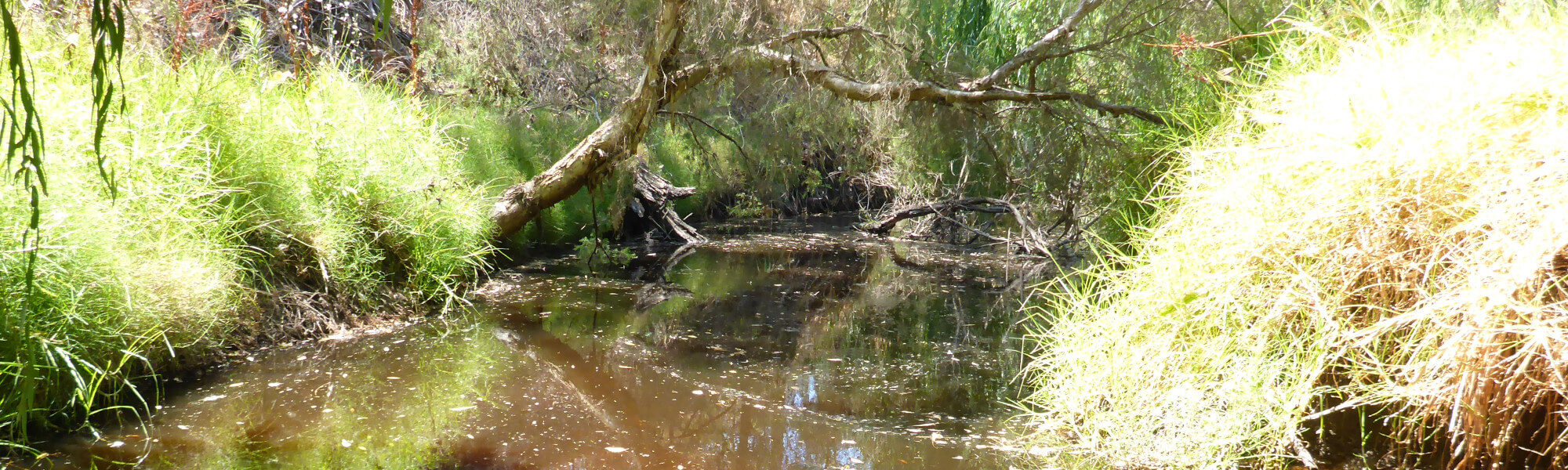
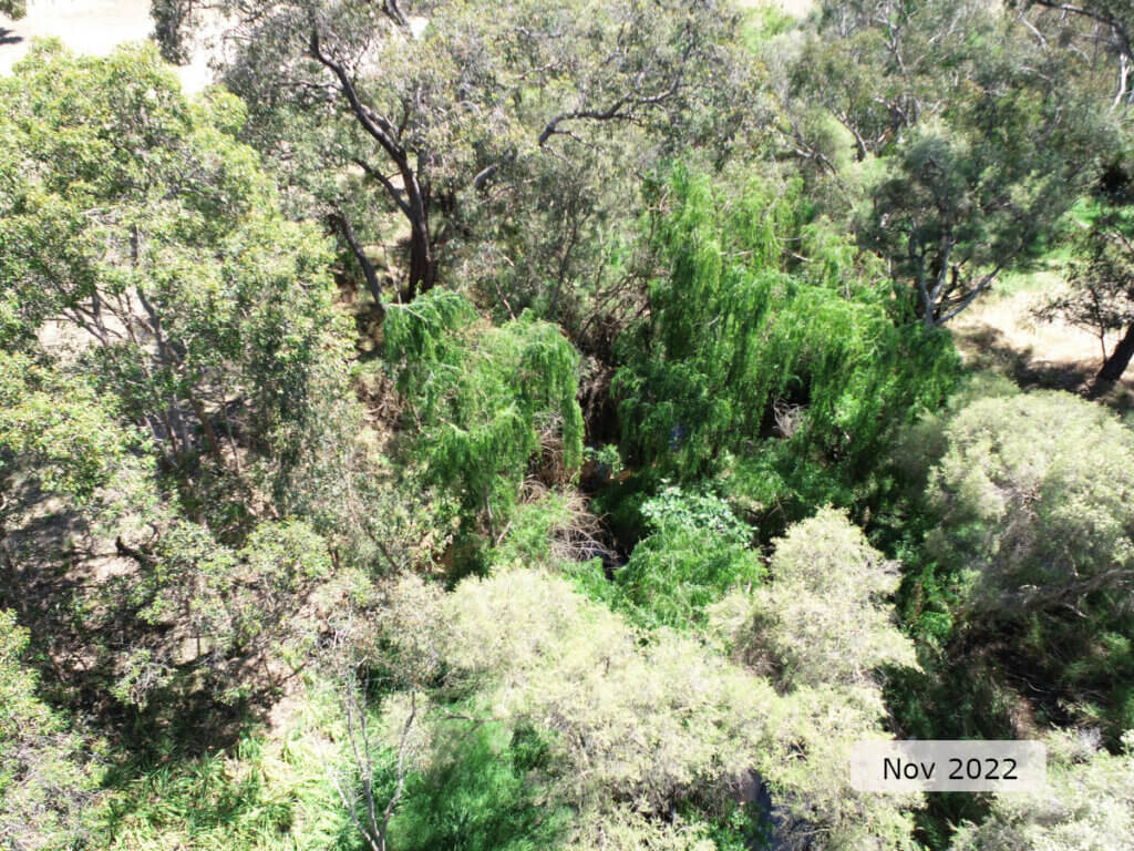
The image below indicates the conditions at the Shearwater Way site in November 2022. November is within the Noongar season of Kambarang (second spring), which is traditionally seen as a transformational time of year with many plants flowering. The season is marked by longer periods of dry weather and rising temperatures. Further images are provided in the gallery at the bottom of the page to show general site conditions, including some from previous assessments.
A summary of site condition over the latest monitoring period is provided in the sections below. For other site data, please contact the department’s River Science team (please reference the site code and sampling dates).
River setting
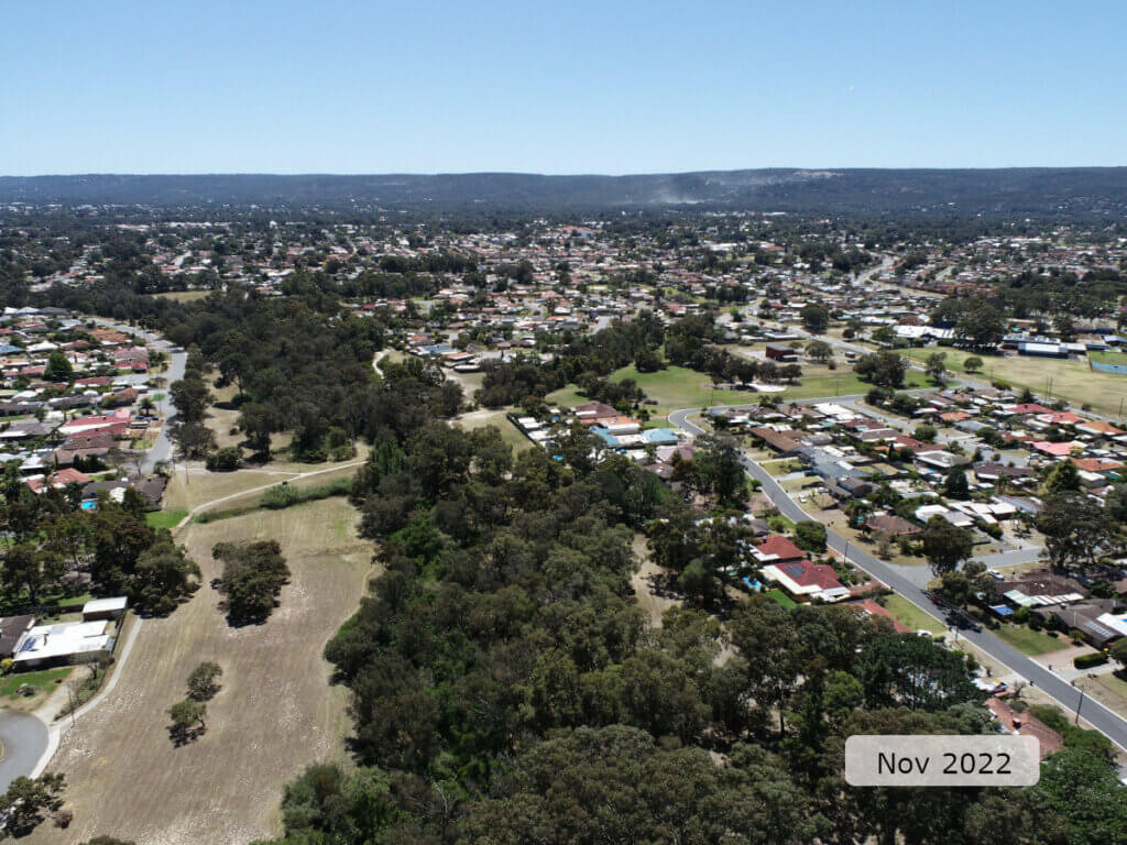
The Shearwater Way site is on the Southern River, a major tributary of the Canning River on the Swan Coastal Plain, about 25 km south of Perth.
The site lies within an urban area and is characteristic of rivers in such settings with an intact, but limited, tree layer and a largely exotic understory. At the time of sampling, it mostly consisted of a channel habitat with some riffle/run-pool sequences, in a moderately steeply incised channel.
Aquatic habitat
At the time of sampling habitat diversity at the site was mostly channel, but with a few short run/riffle sections where dense Salix spp. (willow) roots created much shallower channel depths.
Aquatic habitat quality was mixed. Channel depth and shape were both varied, creating a range of flow and depth conditions to support aquatic fauna. However, the substrate was uniform ‒ mostly sand and silt ‒ with some areas of sediment deposition. Habitat from overhanging banks and roots and vegetation draped in water was limited, accounting for less than half the bank length. In-stream aquatic plants (which provide habitat for fauna) were absent from the site.
Tree canopy shading was optimal through most of the site, extending across the whole channel width. Woody debris was moderately abundant and of 2–3 different sizes (50 cm and above diameter wood being absent), which is slightly reduced from what would be expected in a natural system, but still providing shelter and food for a variety of aquatic fauna.
Flow & connectivity
Discharges from extensive regional groundwater systems in the west of the catchment result in the lower portion of the Southern River maintaining flow during summer. The river flows year-round based on records from the department’s gauging station at Anaconda Drive (site reference 616092) in Gosnells. At the time of sampling the daily discharge at the gauging station was about 9 ML/day. There were sections of high flow (>0.6 m/s), but there were also sufficient rest areas and slower flow areas to allow fish passage through the site.

Vegetation
The riparian zone (containing species adapted to living at the interface between aquatic and terrestrial environments) was severely limited on the left bank (5 m wide) but extended 35 m from the right bank. All vegetation layers were reduced by human impact (urbanisation).
Dominant tree species included Eucalyptus rudis (flooded gum) with some Melaleuca rhaphiophylla (swamp paperbark). Close to the banks and standing within the channel were dense thickets of exotic Salix spp. (willow) – note the bright green canopy in the image below. There was some recruitment of native woody vegetation ‒ limited to trees ‒ but of a limited extent and of only moderate health. The shrub layer was almost absent, and the ground cover layer was largely exotic and was dominated by Watsonia spp. (bugle lily), with pasture grass and other weeds.
Bank stability varied. The right bank was less affected by erosion and had good structural integrity. The left bank, however, was steeper, with erosion affecting more than half the bank length. Left bank stability was rated as poor with exposed roots, steep sandy banks, and damage to property fencing (see below) ‒ all evidence of an unstable and shifting channel bank.
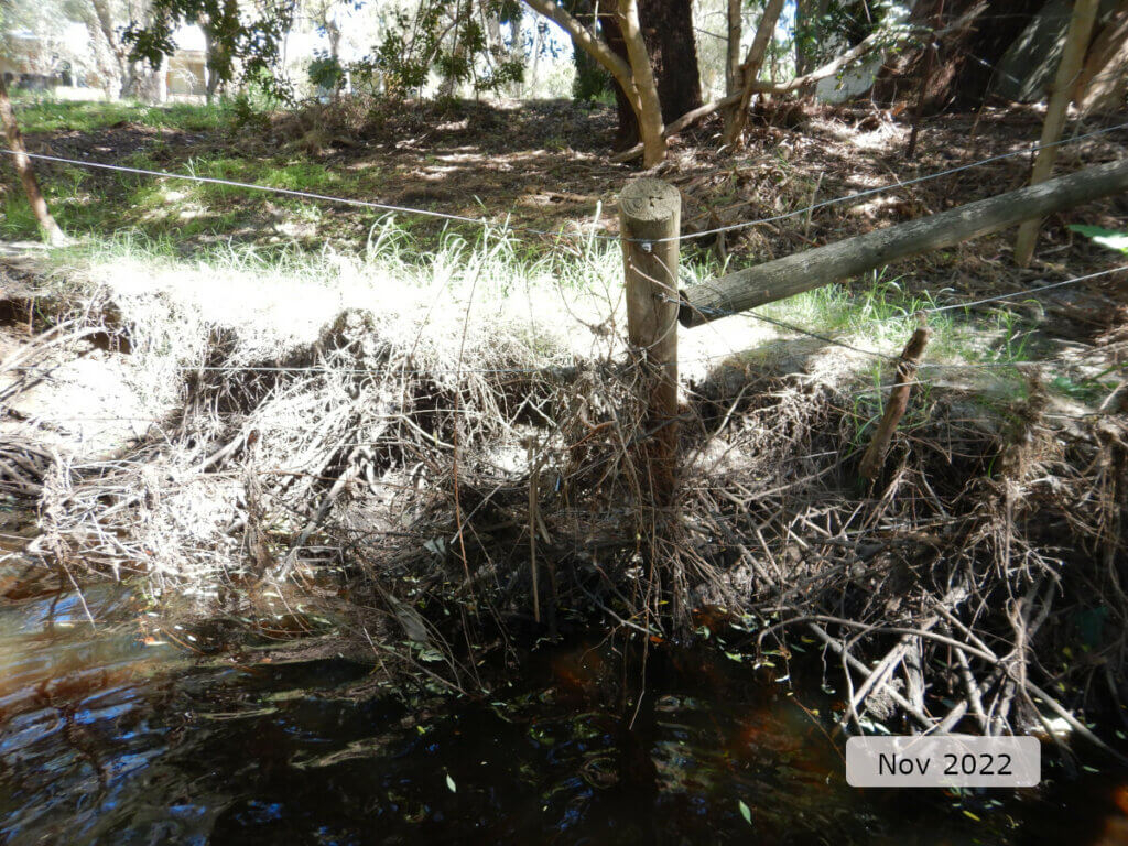
A large sediment slug near the bottom of the site was further evidence of excessive erosion and deposition.
Water quality
Below is a graph of the water quality recorded during the 24-hour assessment.
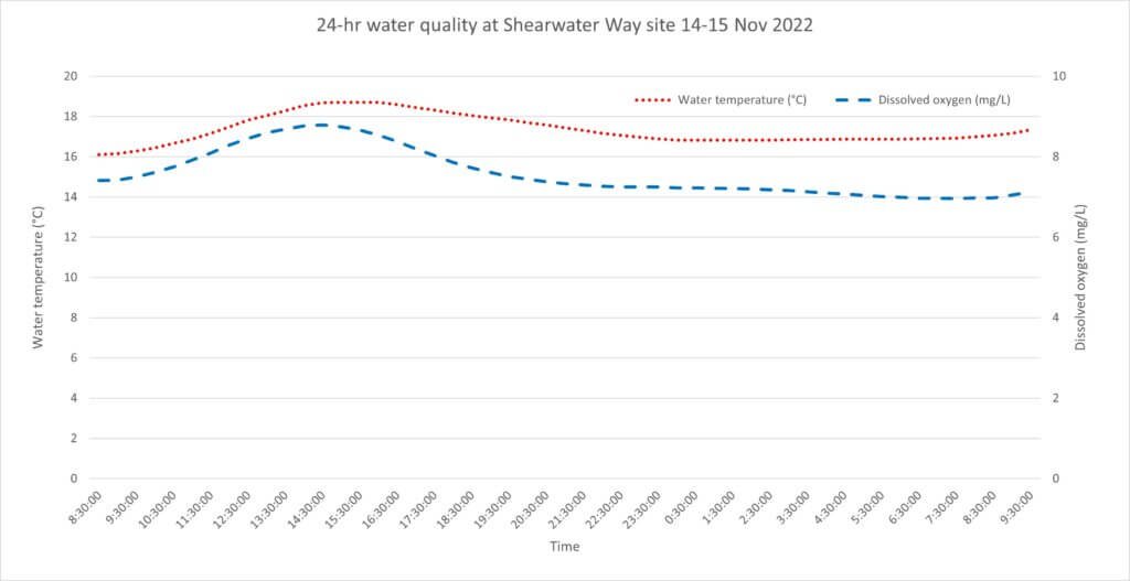
Water quality was optimal. Water temperature did not exceed the 25°C threshold,1 and the diurnal range was also optimal (<4°C). Dissolved oxygen was similarly optimal and remained above the 4 mg/L threshold2 for the entire 24 hours. The small diurnal range in dissolved oxygen (about 2 mg/L) is indicative of a system that was not overly influenced by biological drivers of dissolved oxygen (e.g. algae and/or bacteria) at the time of sampling.
Nutrient concentrations in the water (total nitrogen and total phosphorus) were moderate, likely reflecting some impacts from land uses in the catchment. Specific conductivity (which can be used as an indicator of salinity) was marginal brackish and pH was optimal, based on expectations of natural ranges for freshwater rivers of south-west Western Australia.
Footnote:
1 An upper limit for temperature is nominally set at 25°C based on the range recorded in sites where south-west native fish species are typically found to occur (Beatty et al. 2013).
2 A lower limit of 4 mg/L is taken from the SWIRC where it is used as a guideline limit for condition scoring. This level aligns with Beatty et al. (2013) where south-west native fish species were shown to typically reside in sites with levels above 4 mg/L.
Species found in subcatchment
Native Species
- Blue-spot gobyPseudogobius olorum
- Carter's freshwater musselWestralunio carteri
- Freshwater cobblerTandanus bostocki
- GilgieCherax quinquecarinatus
- NightfishBostockia porosa
- Smooth marronCherax cainii
- South-west glass shrimpPalaemon australis
- South-western snake-necked turtleChelodina colliei
- Western minnowGalaxias occidentalis
- Western pygmy perchNannoperca vittata
Species found at the site
Fish and crayfish
The species recorded at Shearwater Way in 2022 are provided in table 1 below. The table includes a list of all species previously reported in the subcatchment, which provides an indication of species that may occur at the assessment site. As differences in habitat within a subcatchment naturally influence species distributions, and variability in methods between sampling programs can affect the species caught, this list is only indicative.
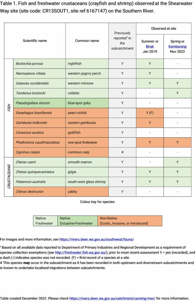
Three species of fish and three species of crustaceans were recorded during the 2022 sampling. This included two endemic fish species (western minnow and freshwater cobbler) and three endemic freshwater crustaceans (smooth marron, gilgie and south-west glass shrimp). The only exotic species recorded was the one-spot livebearer.
Broadly speaking, the aquatic fauna recorded was less diverse in 2022 than in 2019 but this could be because of the difference in the timing of sampling and the movements of different species through the site at different times. Abundance was also reduced in 2022 and was about 15 per cent of that recorded in 2019. This could be attributed to sampling effort (i.e. species were present but were not detected, or species had migrated away from the site at the time). Other influencing factors could include the time of year and movement of species in response to different flows and water levels, or other natural triggers.
The previously recorded nightfish and western pygmy perch were not observed during 2022; however, the larger bodied freshwater cobbler was recorded (but not in 2019). Western minnows were recorded during both the 2019 and 2022 assessments. Smooth marron were also observed during the 2022 assessment but were not recorded in 2019. Looking at exotics, observed species dropped from three in 2019 to one in 2022. Both the eastern gambusia and pearl cichlid were recorded in 2019 (cichlids for the first time) but were not observed in the 2022 assessment.
All of this illustrates that aquatic fauna are mobile and the absence of a species during a particular assessment is not particularly concerning if supporting conditions (e.g. habitat, water quality, and flow/connectivity) have not deteriorated since the previous assessment.
Note: collection of fauna from inland aquatic ecosystems across Western Australia requires a licence from the Department of Primary Industries and Regional Development (DPIRD) and the Department of Biodiversity, Conservation and Attractions (DBCA). All species collected must be reported to these agencies as part of licence conditions.
Other aquatic fauna
Although not targeted by collection methods, the south-western snake-necked turtle (Chelodina oblonga) was recorded at the Shearwater Way site in 2022.
References & recommended reading


Explore other sites in the catchment
- 31 Mile Creek
- Bannister Creek - Bywood Way
- Bannister Creek - Upstream Hybanthus Road
- Bannister Creek - Upstream Iveston Road
- Bannister Creek - Upstream Metcalf Road
- Bickley Brook - Canning River confluence
- Bickley Brook - Davison Road
- Bickley Brook - Eva Street Downstream
- Bickley Brook - Eva Street Upstream
- Bickley Brook - Kenwick Link
- Bickley Brook - Mandarin Road
- Bickley Brook - Upstream BICKBK01A
- Bickley Brook - Upstream Mandarin Road
- Bull Creek - Upstream Corthinian Road
- Canning River - Brookton Highway
- Canning River - Civic Gardens
- Canning River - Corner Pool
- Canning River - Hester Park
- Canning River - Kent St Weir Downstream
- Canning River - Kent St Weir Upstream
- Canning River - Lissiman Street
- Canning River - McNess Drive
- Canning River - Odell Street
- Canning River - Powerline Pool
- Canning River - Seaforth
- Canning River - Stocker Road
- Canning River - Tributary
- Mill Street Main Drain - Palm Place
- Southern River
- Woodlupine Brook Branch Drain
- Wungong Brook - Bruns Drive
- Wungong Brook - South Western Highway
- Wungong River - Wattledale Road
- Wungong River - WUNGRIV01
- Wungong River - WUNGRIV01A
- Wungong River - WUNGRIV05
- Wungong River - WUNGRIV05A
- Yule Brook